
Texas, Oklahoma, Kansas and Missouri Enter Multi-Day Severe Weather Stretch With Hail, Damaging Winds and Tornado Potential Through Saturday
TEXAS, OKLAHOMA, KANSAS AND MISSOURI — An active and potentially dangerous stretch of severe weather is expected to unfold over several days, with storm threats increasing from Thursday through Saturday across parts of the Southern Plains and lower Midwest.
Forecast guidance shows a multi-day setup featuring a strengthening trough, increasing moisture and strong wind shear — ingredients supportive of supercells capable of producing large hail, damaging winds and isolated tornadoes.
Thursday: Initial Severe Setup Across Texas and Oklahoma
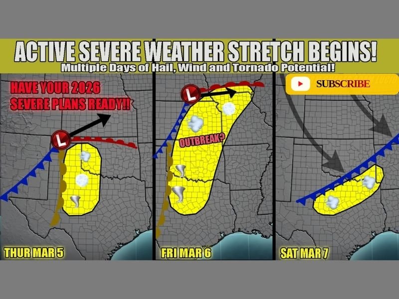
Thursday is shaping up as the first round in what forecasters describe as a “day before the day” scenario. An initial wave of energy ahead of the primary trough is expected to encounter increasing instability across Texas and Oklahoma.
Shear values appear sufficient to support supercell development, with large hail and damaging winds as the primary hazards. However, a tornado cannot be ruled out if storms can organize in the most favorable environment. This initial phase will help set the stage for what could become a more significant event on Friday.
Friday: Main System Expands Risk Into Kansas and Missouri
Friday is projected to be the most concerning day of the stretch. As the main trough ejects eastward and a surface cyclone matures, ingredients for severe weather are expected to spread northward into Kansas and Missouri.
With strong dynamics in place and moisture surging north, all modes of severe weather may be possible, including large hail, damaging winds and tornadoes. If timing and storm evolution align favorably, this could develop into a more widespread severe weather scenario. Cities across eastern Kansas and western to central Missouri will need to monitor forecast updates closely as details become clearer.
Saturday: Lingering Storms Along Trailing Cold Front
By Saturday, the primary low and trough are expected to push east, but a trailing cold front may remain draped across Texas, moving only slowly.
This setup could allow lingering morning storms to continue, followed by potential redevelopment later in the day. Damaging winds appear to be the main concern at this stage, though exact impacts will depend on how the atmosphere recovers after Friday’s activity. Confidence for Saturday remains lower compared to earlier days, but the pattern suggests continued storm potential.
Multiple Days Require Multiple Plans
When severe weather threats extend across several days, preparedness becomes especially important. Residents in Texas, Oklahoma, Kansas and Missouri should review safety plans, ensure warning methods are working and stay aware of updated forecasts.
As systems evolve and track changes become clearer, specific risk areas may shift. However, the overarching message remains consistent: this is an active severe weather stretch with multiple opportunities for impactful storms. For continuing updates on regional severe weather developments and preparedness information, visit NapervilleLocal.com for the latest coverage.

I’ve lived in Naperville long enough to see how quickly our community changes — from new developments downtown to sudden shifts in our Midwest weather. Reporting on Naperville news and daily forecasts gives me the chance to keep neighbors informed about what really matters. My goal is simple: deliver clear, timely updates so you always know what’s happening in our city and what to expect from the skies above.