
Cold Rain and Chilly 40s Grip Michigan Today as Showers Spread Across Lower Peninsula Before Warmer Air Arrives Friday
Michigan — A chilly and damp weather pattern is settling across much of the state today as periods of cold rain move through lower Michigan, bringing gray skies and temperatures struggling to climb beyond the low to mid-40s for many communities.
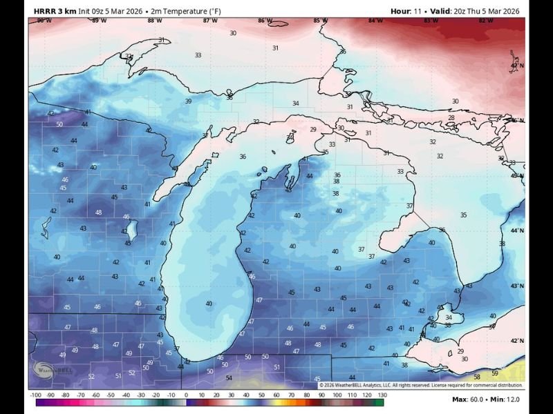
Meteorologists say the best chance of rain showers will occur across southern portions of lower Michigan, particularly south of Mount Pleasant, where cloud cover and persistent showers may keep conditions feeling raw throughout the day.
While rain will be the primary concern, the Upper Peninsula and northern parts of lower Michigan may remain even colder, with temperatures expected to stay below 40 degrees in several locations.
Despite the gloomy conditions today, forecasters say warmer weather is on the way starting Friday, bringing a noticeable improvement across the region.
Rain Showers Focused Across Lower Michigan
Weather models indicate off-and-on rain showers moving across much of lower Michigan, with the highest coverage expected across central and southern areas of the state.
Communities in regions south of Mount Pleasant are most likely to experience periods of steady rain, while northern sections could see lighter precipitation or occasional drizzle.
Cloud cover associated with the system is expected to keep temperatures from rising significantly during the afternoon, reinforcing the chilly feel across the region.
Meteorologists note that cold rain events like this often feel colder than the actual temperature readings, especially when skies remain overcast for much of the day.
Temperatures Struggle to Rise Beyond the 40s
Forecast temperature data shows much of Michigan remaining stuck in the low to mid-40s today, with some areas briefly approaching the upper 40s in the southern parts of the state.
Typical afternoon highs across the region include:
- Southern Lower Michigan: around 44°F to 48°F
- Central Lower Michigan: near 40°F to 44°F
- Northern Lower Michigan: upper 30s to near 40°F
- Upper Peninsula: mostly below 40°F
These temperatures are being reinforced by cool air circulating around the Great Lakes, which often keeps early-spring systems colder across Michigan compared with surrounding regions.
The result is a day where cold rain and cloudy skies dominate the weather pattern across the state.
Warmer Conditions Expected to Arrive Friday
While Thursday’s forecast looks gloomy, meteorologists say a shift toward warmer air will begin arriving Friday, bringing a much more comfortable weather pattern into the region. The warmer air mass is expected to gradually push temperatures upward heading into the weekend, helping to break the stretch of chilly conditions affecting the state today.
As this warmer pattern moves in, many parts of Michigan could see more seasonal temperatures and improving weather conditions, providing relief from the cold rain currently affecting the area. Weather experts say that transitional weather patterns like this are common during early March, when cold systems frequently move through the Great Lakes before warmer spring air begins to establish itself.
Residents across Michigan can expect today’s damp and chilly conditions to gradually give way to a more pleasant forecast in the coming days as the next weather system shifts temperatures upward. For more regional weather updates and detailed forecast coverage across the United States, readers can continue following the latest reports and weather developments on NapervilleLocal.com.

I’ve lived in Naperville long enough to see how quickly our community changes — from new developments downtown to sudden shifts in our Midwest weather. Reporting on Naperville news and daily forecasts gives me the chance to keep neighbors informed about what really matters. My goal is simple: deliver clear, timely updates so you always know what’s happening in our city and what to expect from the skies above.