
Supercell Hail and Tornado Threat Targets Wyoming Colorado and Nebraska Panhandle Today While Damaging Winds and Brief Tornadoes Threaten the East and South
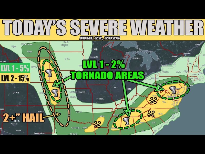
WYOMING — A multi-zone severe weather outbreak is underway today across several regions of the country, with the primary threat centered on the high plains of Wyoming, Colorado, and the Nebraska Panhandle. High-based supercells are expected across this corridor capable of all severe weather modes, with very large hail measuring two inches or greater as the dominant threat.
Some tornado potential exists from both landspouts and brief mesocyclonic tornadoes, carrying a Level 2 risk at 15 percent probability in the highest zone. Conditions today do not favor the widespread destructive straight-line winds seen over the past couple of days in this region.
High Plains Supercells Carry Level 2 Hail and Tornado Risk
The primary severe weather area across Wyoming, Colorado, and the Nebraska Panhandle carries a Level 2 risk with a 15 percent tornado probability, alongside a significant two-inch-plus hail threat. High-based supercells developing this afternoon will be capable of producing very large hailstones, with tornado potential from both landspouts and brief mesocyclonic circulations.
Decaying MCS May Produce Gusts Near Texarkana
A slowly decaying mesoscale convective system, responsible for damaging winds overnight across Kansas and Oklahoma, is expected to produce a few wind gusts near the Texarkana area before completely dissipating later this morning. This remnant threat is short-lived but worth monitoring for communities in that vicinity early today.
Eastern and Southern Storms Re-Ignite From Yesterday’s System
Across the East and South, yesterday’s storm system is expected to re-ignite scattered severe storms today, though not as potent as the previous day’s outbreak. Damaging winds and a brief tornado or two remain possible across highlighted areas from the Mid-South through the Mid-Atlantic, carrying a Level 1 tornado risk at 2 percent probability.
Tornado Areas Highlighted From Plains to East Coast
Multiple dashed tornado threat zones are identified today stretching from the Wyoming and Colorado high plains eastward through the Midwest and into the Mid-Atlantic and Carolinas. Residents across all highlighted zones are urged to remain weather aware throughout the afternoon and evening hours.
Stay with NapervilleLocal.com for the latest weather updates and local forecast coverage.

I’ve lived in Naperville long enough to see how quickly our community changes — from new developments downtown to sudden shifts in our Midwest weather. Reporting on Naperville news and daily forecasts gives me the chance to keep neighbors informed about what really matters. My goal is simple: deliver clear, timely updates so you always know what’s happening in our city and what to expect from the skies above.