
Sea Breeze Storms Could Trigger Thunderstorms and Lightning Across Florida’s Gulf Coast Near Tampa, Sarasota, and Naples Today
Florida — Meteorologists are tracking a pattern of summer-style thunderstorms expected to develop across parts of Florida today, particularly along the state’s west coast near the Interstate 75 corridor, where sea breeze boundaries could trigger clusters of showers and lightning-producing storms.
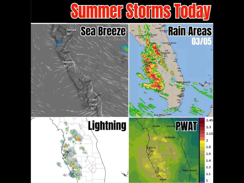
Forecasters say the setup resembles a typical Florida summer thunderstorm pattern, where warm temperatures and moist air combine with sea breeze winds moving inland from the Gulf of Mexico.
These conditions could allow scattered thunderstorms to develop during the afternoon, especially across communities stretching from Tampa and Sarasota south toward Naples and Cape Coral. While not expected to become a widespread severe weather event, some storms could produce heavy rain, lightning, and possibly isolated hail in stronger thunderstorm cells.
Sea Breeze Collision Expected to Trigger Storm Development
Weather models show sea breeze winds moving inland from the Gulf Coast, where they may collide with inland air masses and trigger thunderstorm formation during the afternoon. This phenomenon — often called a sea breeze collision — is one of the most common drivers of Florida’s afternoon storms.
Areas near Tampa, Sarasota, and Cape Coral could see developing storm clouds as the breeze moves inland. These storms often begin as small rain showers but can quickly grow into thunderheads capable of producing lightning and heavy rainfall.
Meteorologists say the storm clusters may form in scattered groups, meaning some areas could receive significant rainfall while nearby communities remain dry.
Lightning and Heavy Downpours Possible in Stronger Storms
Forecast lightning models already indicate active thunderstorm development potential across portions of western and central Florida.
When thunderstorms form in this environment, they may produce several hazards including:
- Frequent lightning
- Short bursts of heavy rain
- Localized gusty winds
- Isolated hail in stronger storms
Although hail is not expected to be widespread, meteorologists note that larger storm cells could briefly produce small hail if thunderclouds grow tall enough in the unstable atmosphere. Another factor being monitored is the slow movement of storms once they develop, which could allow rain showers to linger over certain areas.
High Moisture Levels Supporting Storm Formation
One of the key atmospheric indicators supporting today’s thunderstorm development is high precipitable water (PWAT) values, which measure the amount of moisture available in the atmosphere.
Forecast maps show elevated moisture levels across central and southern Florida, particularly near Naples, Tampa, and Orlando, indicating that the atmosphere contains enough humidity to support rain-producing storms.
High PWAT levels often mean thunderstorms can produce heavier rainfall and more active lightning, especially when combined with daytime heating. Because winds in the upper atmosphere are relatively weak, meteorologists say storms could move slowly once they form, allowing localized rain pockets to develop.
Storms Likely to Remain Isolated and Short-Lived
Despite the potential for thunderstorm development, forecasters say the storms are expected to remain scattered rather than widespread, meaning not every community will experience rain today.
The storms will likely follow a typical Florida pattern, forming during the afternoon before gradually weakening toward the evening hours. This pattern is common when sea breeze interactions and warm, moisture-rich air combine during the daytime heating cycle.
Residents across western and central Florida should still remain aware of the possibility of sudden lightning, brief heavy rain, and localized storms developing during the afternoon hours. For continued updates on developing weather conditions and regional forecast coverage across the United States, readers can follow the latest weather reports on NapervilleLocal.com.

I’ve lived in Naperville long enough to see how quickly our community changes — from new developments downtown to sudden shifts in our Midwest weather. Reporting on Naperville news and daily forecasts gives me the chance to keep neighbors informed about what really matters. My goal is simple: deliver clear, timely updates so you always know what’s happening in our city and what to expect from the skies above.