
Oklahoma, Arkansas and Northeast Texas Severe Weather Alert: Tornado Risk Rising From Denison and McAlester Through Fayetteville Toward Springfield Friday Evening
MCALESTER, OKLAHOMA — Severe weather conditions are expected to develop later today across parts of southeast Oklahoma, western Arkansas, and northeast Texas as a powerful storm system interacts with warm, unstable air across the region. Forecasters warn that storms forming later this afternoon and evening could become capable of producing tornadoes, large hail, and damaging wind gusts.
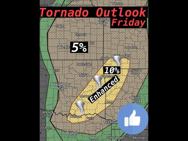
The latest outlook highlights a corridor of enhanced tornado risk stretching from Denison in northeast Texas through McAlester in southeast Oklahoma and into Fayetteville, Arkansas, extending toward Springfield, Missouri.
Storms Expected to Develop After 4 PM
Meteorologists say thunderstorms are likely to begin developing after 4 PM, when atmospheric conditions become favorable for strong storm formation.
As the approaching system moves into the region, warm and unstable air already in place will provide the fuel needed for thunderstorms to rapidly intensify. Once storms begin forming, some could quickly organize into supercells, which are rotating thunderstorms known for producing tornadoes and severe weather.
Corridor of Greatest Tornado Concern
Forecast analysis indicates the highest tornado risk lies along a zone stretching from Denison and Paris in northeast Texas through McAlester, Oklahoma, and northeast toward Fayetteville, Arkansas.
Storms that develop in this corridor may rotate more easily due to strong wind shear present in the atmosphere. This rotation increases the likelihood that some storms could produce tornadoes.
The tornado probability in the enhanced zone is estimated to reach around 10 percent, indicating a meaningful risk for tornado development in this region.
Large Hail and Damaging Winds Also Possible
In addition to tornadoes, storms could also produce large hail and damaging wind gusts as they intensify during the evening hours.
Hailstones could become significant in size within the strongest storms, while powerful wind gusts may cause tree damage and localized power outages in affected communities. Even storms that do not produce tornadoes could still bring hazardous conditions across the region.
Tulsa Area Faces Lower but Present Risk
While the greatest concern lies farther south and east, areas around Tulsa and much of northeast Oklahoma remain within a lower tornado probability zone.
Forecasters say tornado risk in these areas is lower but not zero, and storms moving east of the metro area could still produce strong winds and hail. Residents across the region should remain alert as storm development begins later this afternoon.
Forecast Confidence Still Evolving
Meteorologists caution that the exact coverage and intensity of storms may become clearer as the day progresses. While the environment supports severe weather, the number of storms that actually form could determine how widespread the impacts become.
Even a few storms developing in the highlighted corridor could quickly become severe. Officials encourage residents across southeast Oklahoma, western Arkansas, and northeast Texas to stay updated with local forecasts and be prepared to act quickly if severe weather warnings are issued later today.

I’ve lived in Naperville long enough to see how quickly our community changes — from new developments downtown to sudden shifts in our Midwest weather. Reporting on Naperville news and daily forecasts gives me the chance to keep neighbors informed about what really matters. My goal is simple: deliver clear, timely updates so you always know what’s happening in our city and what to expect from the skies above.