
Late-Season Snow Signal Emerging Across Michigan, Wisconsin, Indiana, Ohio, Pennsylvania and New York Before Spring Begins
GREAT LAKES REGION — Winter may not be finished across the northern United States just yet. Long-range weather guidance suggests that another active weather pattern could bring the possibility of measurable snowfall across parts of the Great Lakes and Northeast before the official start of spring.
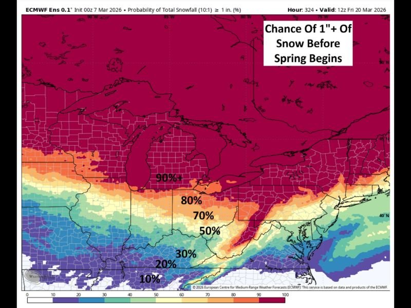
Meteorologists analyzing extended forecast models say several storm systems combined with colder air could create conditions supportive of snow across a wide portion of the northern United States in the coming days.
High Probability of Snow Across the Great Lakes
Forecast model data shows a strong probability that many areas across the Great Lakes region, including Michigan and Wisconsin, could see measurable snowfall before spring arrives.
Probability projections indicate greater than 90 percent chances in parts of the region for at least one inch of snow before the seasonal transition.
This high probability zone stretches across much of the northern Midwest and into portions of the interior Northeast.
Snow Chances Extend Into Indiana, Ohio and Pennsylvania
The probability zone gradually decreases farther south but still remains significant across states including Indiana, Ohio, and Pennsylvania.
In these areas, the chance of receiving one inch or more of snowfall ranges between 70 percent and 80 percent, indicating a strong likelihood that late-season snow could still occur.
Even areas slightly farther south continue to show measurable probabilities, meaning storm tracks could shift the snow zone depending on how upcoming systems evolve.
Lower Probabilities Toward the Southern Edge
Farther south of the main snow zone, probabilities begin to decline but still remain present.
Parts of the southern Midwest and lower Ohio Valley show 30 percent to 50 percent chances of receiving measurable snow before the first day of spring.
These lower percentages highlight the uncertainty in long-range forecasting, where slight changes in storm paths or temperatures can significantly impact snowfall distribution.
Heavy Snow Still Possible in Some Areas
Forecast models also suggest that some regions within the higher probability zone could potentially see heavier snowfall totals if stronger storm systems develop.
Current long-range signals indicate that the chance of three inches or more of snow in some areas remains just above 50 percent, suggesting the possibility of more impactful late-season winter weather.
However, meteorologists stress that exact snowfall amounts and locations will depend on how future storm systems track across the region.
Active Weather Pattern Expected Late in Winter
Weather experts say the developing pattern indicates a series of storm systems moving across the country during the final stretch of winter.
If colder air remains in place as these systems pass through the northern United States, conditions could support additional snowfall across portions of the Great Lakes and Northeast.
While details remain uncertain this far out, the long-range forecast signals suggest that winter weather may still make a return before spring officially begins.

I’ve lived in Naperville long enough to see how quickly our community changes — from new developments downtown to sudden shifts in our Midwest weather. Reporting on Naperville news and daily forecasts gives me the chance to keep neighbors informed about what really matters. My goal is simple: deliver clear, timely updates so you always know what’s happening in our city and what to expect from the skies above.