
Severe Thunderstorm Warning Across Northwest Georgia: 60 MPH Winds Threaten Rome, Carrollton, Cartersville and Surrounding Communities
GEORGIA — The National Weather Service in Peachtree City has issued a Severe Thunderstorm Warning for several counties in northwest Georgia, as a line of powerful storms pushes southeast across the region with the potential for damaging wind gusts. The warning covers parts of Paulding, Haralson, Carroll, Floyd, Polk, and Bartow counties and remains in effect until 10:00 PM EDT.
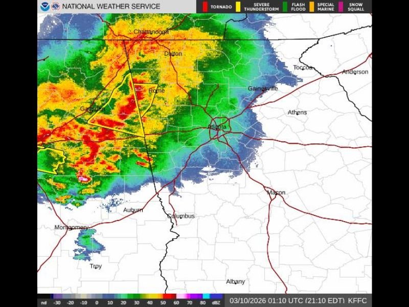
Radar imagery shows a strong line of storms extending from near Coosa to Cave Spring and Oak Level, moving southeast at approximately 40 miles per hour. Meteorologists warn that the storms could produce wind gusts up to 60 mph, strong enough to cause property damage.
Storm Line Moving Southeast Through Northwest Georgia
At around 9:16 PM EDT, radar indicated a well-organized line of severe thunderstorms advancing across northwest Georgia. The storm system is tracking southeast and could affect numerous communities across the region as it continues to move.
Cities and towns expected to be impacted include:
- Rome
- Carrollton
- Cartersville
- Dallas
- Cedartown
- Buchanan
- Bremen
- Temple
- Rockmart
- Euharlee
- Tallapoosa
- Mount Zion
- Aragon
- Kingston
- Waco
- Braswell
- Taylorsville
- Shannon
- Yorkville
- Draketown
Residents in these areas could experience strong winds, intense rainfall, and dangerous lightning as the storm line moves through.
60 MPH Wind Gusts Could Cause Damage
The primary threat with these storms is damaging straight-line winds, which may reach 60 miles per hour in some areas.
According to the National Weather Service, such wind speeds can:
- Damage roofs and siding on homes
- Knock down tree limbs or entire trees
- Cause scattered power outages
- Create hazardous travel conditions
Radar data indicates the storms are already producing strong wind signatures as they sweep across the region.
Radar Shows Strong Storm Complex Approaching Metro Atlanta Region
Weather radar imagery reveals a large complex of storms stretching from eastern Alabama through northwest Georgia, with the strongest activity currently positioned near Rome and areas west of Atlanta. As the storms move southeast, communities closer to the Atlanta metro region could also experience periods of heavy rain and gusty winds later in the evening.
Residents Urged to Remain Alert
Meteorologists are advising residents across northwest Georgia to remain alert for rapidly changing weather conditions as the storm system continues to move through. People in the warning area should monitor local weather updates and be prepared to move indoors if severe winds approach.
Staying away from windows, securing outdoor objects, and avoiding travel during the strongest part of the storm can help reduce the risk of injury or property damage as the severe weather moves across the region.

I’ve lived in Naperville long enough to see how quickly our community changes — from new developments downtown to sudden shifts in our Midwest weather. Reporting on Naperville news and daily forecasts gives me the chance to keep neighbors informed about what really matters. My goal is simple: deliver clear, timely updates so you always know what’s happening in our city and what to expect from the skies above.