
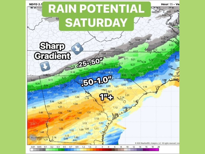
Sharp Rain Gradient Splits Saturday Forecast With Misty Showers North of I-85 and Soaking 1 Inch Plus Totals South Toward Columbia and the Coast
CAROLINAS — A sharp and well-defined rain gradient will divide Saturday’s precipitation picture into two very different stories depending on location relative to Interstate 85. North of I-85, conditions will trend toward misty, on-and-off showers with lighter totals that accumulate slowly throughout the day. South of I-85 and toward the coast, steadier and more meaningful rainfall is expected, with totals approaching and exceeding 1 inch in areas closest to the low pressure system tracking near Columbia and the coastline.
North of I-85 Sees Misty and On-and-Off Showers With Lighter Rain Totals Saturday
Residents north of I-85 will experience a drizzly and grey Saturday without the heavier and more sustained rainfall found further south. Rain totals across the northern zone are forecast in the 0.25 to 0.50 inch range, accumulating slowly through on-and-off shower activity rather than any prolonged or steady rainfall period.
The sharp gradient shown on forecast modeling makes this one of those setups where neighboring communities can see dramatically different rainfall outcomes based purely on their position relative to the I-85 corridor. Communities just north of the line should not expect the beneficial soaking rain that their neighbors to the south will receive through the course of Saturday.
South of I-85 Delivers Steady and Meaningful Rain With Totals Reaching 1 Inch Plus
South of I-85, the rain story intensifies significantly, with steady and meaningful rainfall producing totals in the 0.50 to 1.0 inch range across a broad swath of the southern zone. Areas closest to Columbia and along the coast are forecast to see totals exceeding 1 inch, with some localized spots approaching and surpassing 1.50 inches where the low pressure system maintains its strongest moisture feed.
The heaviest totals remain favored from Columbia toward the coast, where the proximity to the low pressure center keeps rainfall steady and persistent through much of Saturday. This is genuinely beneficial rain for the southern portions of the region, delivering meaningful moisture to areas that can put it to good use.
Sharp Gradient Makes Saturday a Tale of Two Very Different Rain Experiences
The defining feature of Saturday’s forecast is how dramatically conditions differ over relatively short distances. The sharp gradient running along and near the I-85 corridor creates a clear dividing line between the misty north and the soaking south, making this one of the more split and uneven precipitation setups of the season so far.
Residents should check their specific location against the forecast gradient carefully before finalizing any Saturday outdoor plans, as the difference between 0.10 inches of drizzle and 1.25 inches of steady rain is significant and entirely dependent on which side of I-85 they fall. Stay with NapervilleLocal.com for the latest weather updates and local forecast coverage.

I’ve lived in Naperville long enough to see how quickly our community changes — from new developments downtown to sudden shifts in our Midwest weather. Reporting on Naperville news and daily forecasts gives me the chance to keep neighbors informed about what really matters. My goal is simple: deliver clear, timely updates so you always know what’s happening in our city and what to expect from the skies above.