
Illinois Supercell Triggers Severe Thunderstorm Warning With 4-Inch Hail Threat Near Kankakee, Bourbonnais, Momence, and St. Anne
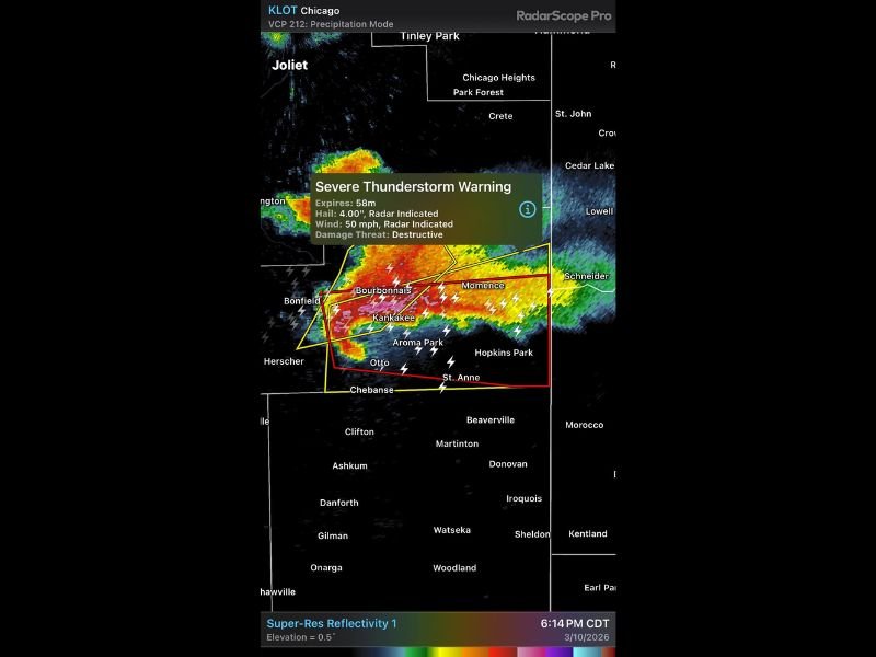
KANKAKEE COUNTY, ILLINOIS — A dangerous supercell thunderstorm moving across northeastern Illinois Tuesday evening triggered a Severe Thunderstorm Warning with radar-indicated hail up to 4 inches in diameter, placing several communities south of the Chicago metro area in the path of destructive weather.
Radar imagery around 7:18 p.m. showed the storm intensifying near Bourbonnais and Kankakee, with the warning area extending east toward Momence and south toward St. Anne and Aroma Park.
Radar Indicates Potential for Destructive 4-Inch Hail
Weather radar from the KLOT Chicago radar site detected strong storm structure capable of producing extremely large hail, with warning information indicating hail potentially reaching 4 inches in diameter. Hail of this size can cause severe damage to vehicles, roofs, and windows and poses serious danger to anyone caught outdoors.
The radar signature suggests a classic supercell thunderstorm, where a powerful rotating updraft allows hailstones to grow unusually large before falling to the ground. Communities within the warning area, including Kankakee, Bourbonnais, Momence, and Aroma Park, could experience intense bursts of large hail as the storm moves through.
Strong Winds and Heavy Rain Also Possible
In addition to the large hail threat, the warning indicates radar-detected wind gusts up to 50 mph, which could lead to downed tree limbs and localized power outages.
Heavy rainfall and frequent lightning were also visible within the storm core, particularly across the western portion of the warning area near Bonfield and Bourbonnais. Storms of this nature often produce intense rainfall rates that can temporarily reduce visibility for drivers and create minor roadway flooding in low-lying areas.
Tornado Potential Along Southern Edge of the Storm
Meteorologists also noted that the southern flank of the storm may contain rotating elements capable of producing tornadoes. This rotating portion of a supercell is often located along the southern edge of the storm structure, where warm air feeds into the system and supports storm rotation.
Areas near St. Anne and Hopkins Park could see the most active rotation as the storm progresses eastward. While tornado development is not guaranteed, the structure of the storm suggests conditions that support severe weather development.
Storm Continues Tracking Across Northeastern Illinois
The storm is expected to continue moving east across Kankakee County and surrounding communities, impacting towns along the Illinois–Indiana border corridor.
Residents in Bourbonnais, Kankakee, Momence, Aroma Park, and St. Anne should remain alert for rapidly changing weather conditions and be prepared to seek shelter if conditions worsen. Meteorologists will continue monitoring the storm closely as it moves across northeastern Illinois Tuesday evening, with additional warnings possible if the storm continues to intensify.

I’ve lived in Naperville long enough to see how quickly our community changes — from new developments downtown to sudden shifts in our Midwest weather. Reporting on Naperville news and daily forecasts gives me the chance to keep neighbors informed about what really matters. My goal is simple: deliver clear, timely updates so you always know what’s happening in our city and what to expect from the skies above.