
Powerful Cold Front Sweeps Across Wyoming and Nebraska With 50+ MPH Winds Near Casper, Snow Developing Toward Laramie and Cheyenne
CASPER, WYOMING — A powerful cold front is sweeping east across Wyoming and Nebraska Tuesday evening, bringing wind gusts exceeding 50 mph near Casper while rapidly dropping temperatures into the 20s and 30s behind the front.
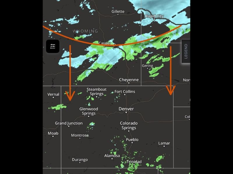
Weather radar shows scattered showers forming across the region as the system continues moving eastward, signaling a shift toward colder conditions across portions of the central Rockies and High Plains.
Strong Winds and Rapid Temperature Drop Behind the Front
As the cold front pushes through central Wyoming, winds have intensified significantly around the Casper area, with gusts topping 50 mph.
These strong winds are being driven by the sharp pressure gradient along the advancing front, which is pushing colder air southward and eastward across the region. Behind the front, temperatures have already fallen into the upper 20s and 30s, marking a noticeable change from earlier conditions.
Showers and Isolated Thunderstorms Across Colorado and Kansas
Ahead of the cold front, scattered showers and a few isolated thunderstorms have developed across far southern Colorado and southwest Kansas.
These storms remain relatively limited in coverage but align with earlier forecasts that suggested moisture and instability would support isolated precipitation along the southern portion of the system. Communities across southern Colorado may continue to see intermittent rain showers as the system progresses.
Snow Developing Across Wyoming’s Mountain Corridors
In the colder air behind the front, precipitation is expected to transition to snow showers across the central and northern Wyoming mountains.
Along the Interstate 80 corridor, precipitation may change from rain to snow or a rain-snow mix, particularly across areas stretching from Rock Springs to Rawlins to Laramie and Cheyenne. This transition reflects colder air filtering into the region as the cold front continues advancing east.
Precipitation Expected to Move Toward Western Nebraska
Forecasters expect the precipitation band to shift eastward into the western Nebraska panhandle between roughly 9 p.m. and midnight. As the front continues its march across the Plains, scattered showers may briefly increase in coverage before gradually weakening overnight.
Possible Rain-to-Snow Mix Along the Front Range
Across Colorado’s Front Range and the Interstate 25 corridor, forecasters say a few showers could mix with or transition to wet snow after midnight, particularly in areas north of Denver and across the northeast plains. Any precipitation that develops may persist into Wednesday morning, though conditions are expected to improve as drier air moves into the region.
Cooler Temperatures Expected Wednesday
Following the passage of the front, cooler air will settle across the region Wednesday with daytime highs expected mainly in the 40s and 50s.
Meteorologists note that conditions may change again later in the week, with strong winds and warmer temperatures expected to return by Thursday. Forecasters will continue monitoring the evolving weather pattern as the cold front progresses across the Rockies and into the Plains overnight.

I’ve lived in Naperville long enough to see how quickly our community changes — from new developments downtown to sudden shifts in our Midwest weather. Reporting on Naperville news and daily forecasts gives me the chance to keep neighbors informed about what really matters. My goal is simple: deliver clear, timely updates so you always know what’s happening in our city and what to expect from the skies above.