
Massive Weekend Storm Could Slam the Midwest With Blizzard Snow, Severe Thunderstorms, and 40 MPH Winds on Sunday
MIDWEST, UNITED STATES — A powerful weather system expected to move across the central United States this weekend could bring a rare combination of blizzard conditions, heavy snow, and severe thunderstorms across multiple states on Sunday, creating a potentially chaotic weather setup across the Midwest and Great Lakes.
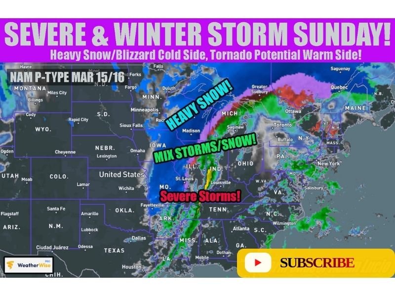
Meteorologists say the system could produce two very different types of dangerous weather depending on location, with severe storms developing on the warm side of the system while heavy snow and strong winds hammer areas on the colder side.
Severe Thunderstorms Possible Across the Southern Midwest
Forecast models suggest the southern portion of the storm system may produce severe thunderstorms as warm, unstable air spreads northward ahead of the approaching system.
Areas from Arkansas through Missouri, Illinois, and into parts of Tennessee and Kentucky could see strong thunderstorms capable of producing damaging winds and possibly tornadoes. This severe weather threat would develop along the warm side of the system as the storm intensifies and moves east.
Heavy Snow and Blizzard Conditions Possible Across the Upper Midwest
On the colder side of the storm, conditions could shift dramatically as the system wraps colder air into the region. Forecast projections indicate heavy snowfall could develop across parts of Iowa, Wisconsin, and Michigan, with some areas potentially experiencing blizzard-like conditions. Strong winds wrapping around the system may reach around 40 mph, which could lead to blowing snow and reduced visibility if heavy snow develops.
Some Midwest Areas Could Experience Both Storm Types
Meteorologists say parts of the Midwest could briefly experience both severe storms and snow from the same system, depending on how the storm evolves.
Some areas may see rain and thunderstorms initially, followed by colder air wrapping in behind the system that could change precipitation over to snow. This type of setup can lead to rapidly changing weather conditions over a short period of time.
Large Portion of the Central and Eastern U.S. Could Feel Impacts
Early model projections show the storm system stretching across a wide region from the central Plains through the Midwest and into parts of the Great Lakes and Northeast. Heavy snow could extend north toward Michigan and parts of the Great Lakes region, while severe storms develop farther south across portions of the Mississippi Valley and Tennessee Valley.
Forecast Still Evolving Ahead of the Weekend
While the overall setup for a significant storm system is becoming clearer, meteorologists caution that details regarding the exact placement of heavy snow, severe storms, and potential blizzard conditions may continue to change over the coming days. Forecasters will be monitoring how the storm develops as it approaches the Midwest this weekend, with additional updates expected as models refine the track and intensity of the system.

I’ve lived in Naperville long enough to see how quickly our community changes — from new developments downtown to sudden shifts in our Midwest weather. Reporting on Naperville news and daily forecasts gives me the chance to keep neighbors informed about what really matters. My goal is simple: deliver clear, timely updates so you always know what’s happening in our city and what to expect from the skies above.