
Alabama Severe Storm Threat Builds Late Sunday Night as Damaging Winds and Possible Tornadoes Target Birmingham, Montgomery, and Huntsville
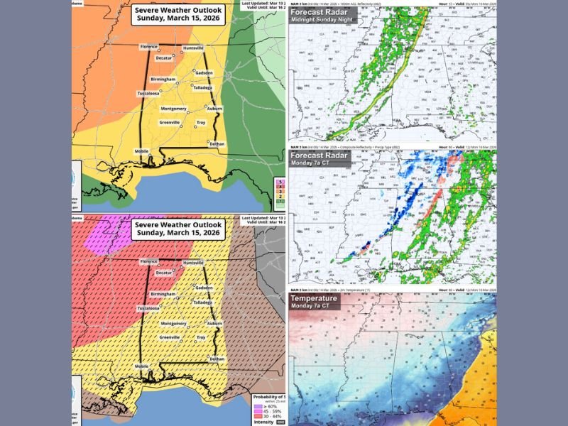
BIRMINGHAM, ALABAMA — A developing line of severe thunderstorms is expected to sweep across Alabama late Sunday night into early Monday morning as a strong cold front pushes south through the state. Meteorologists warn the system could bring damaging winds and isolated tornadoes to several major cities, including Birmingham, Montgomery, Huntsville, and Tuscaloosa.
The storms are forecast to move quickly across the state overnight, potentially affecting millions of residents while many are sleeping.
Storm Line Expected to Enter Northwest Alabama Around Midnight
Forecasters say the severe weather threat will begin in the northwest corner of Alabama late Sunday night. The leading edge of the storms could reach communities near Florence, Decatur, and Huntsville around midnight.
From there, the line of storms is expected to move steadily southward through central Alabama overnight. Areas including Birmingham, Tuscaloosa, Gadsden, and Talladega could experience the strongest storms as the system progresses across the state. Meteorologists warn that damaging straight-line winds may be the primary hazard as the storms move through.
Tornadoes Also Possible Within the Storm Line
While damaging winds are expected to be the most widespread threat, forecasters say a few tornadoes cannot be ruled out within the line of storms. The severe weather outlook highlights much of central and western Alabama, including Birmingham and Tuscaloosa, in a higher probability zone for severe weather.
Cities such as Montgomery, Greenville, Auburn, Troy, and Dothan may also see strong storms as the system continues toward the southeastern portion of the state before sunrise Monday. Officials say residents should remain alert for overnight weather warnings and have ways to receive alerts if severe weather develops.
Storms Expected to Clear Alabama by Early Monday Morning
The fast-moving line of storms is expected to push across the entire state within a few hours. Current forecasts suggest the system will enter northwest Alabama near midnight and exit the southeastern corner of the state by around 6 a.m. Monday.
Because the storms will occur overnight, meteorologists stress the importance of staying informed and ensuring weather alerts are enabled on phones or weather radios.
Much Colder Air Will Follow the Storm System
Behind the cold front, temperatures across Alabama are expected to drop quickly early Monday morning. Forecast models show much colder air spilling into the region after the storms pass. Some parts of northern Alabama, including areas around Huntsville and Decatur, could even see light snow flurries or brief snow showers Monday morning. However, forecasters currently expect no snow accumulation or significant impacts from those flurries.
Residents Urged to Monitor Weather Updates
With severe storms expected to develop overnight, weather officials are urging Alabama residents to closely monitor updates throughout the weekend. Strong winds, heavy rain, and isolated tornadoes remain possible as the storm line sweeps across the state late Sunday night into Monday morning.
Forecasters say the situation will continue to be monitored closely as new data becomes available, and additional updates could be issued if the severe weather threat changes.

I’ve lived in Naperville long enough to see how quickly our community changes — from new developments downtown to sudden shifts in our Midwest weather. Reporting on Naperville news and daily forecasts gives me the chance to keep neighbors informed about what really matters. My goal is simple: deliver clear, timely updates so you always know what’s happening in our city and what to expect from the skies above.