
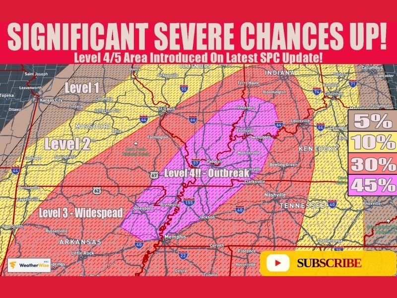
Illinois and Indiana Brace for Significant Severe Storm Threat Sunday as Level 4 Outbreak Risk Extends Into Arkansas and Tennessee
INDIANAPOLIS, INDIANA — Meteorologists are warning that a potentially significant severe weather outbreak could develop Sunday across parts of the Midwest and Mid-South, with a high-risk corridor stretching through Illinois, Indiana, Arkansas, and Tennessee. The latest outlook highlights a Level 4 out of 5 severe weather risk, indicating the possibility of widespread damaging storms capable of producing destructive winds and tornadoes. Forecasters say the threat zone forms a corridor from northeastern Arkansas through western Tennessee and Kentucky into southern Indiana and portions of Illinois.
Level 4 Severe Risk Highlights Potential Outbreak Zone
According to the latest forecast outlook, the most dangerous severe weather conditions are expected within a Level 4 “Moderate Risk” area, which signals an elevated potential for a widespread severe storm event.
Cities located near the projected corridor include Memphis in Tennessee, Evansville in Indiana, and communities across southern Illinois and western Kentucky. Meteorologists say this type of outlook is typically issued when conditions support organized storm systems capable of producing large-scale impacts.
Squall Line Could Produce Destructive Winds Over 70 MPH
Forecasters expect the storms to organize into a powerful squall line, a fast-moving line of thunderstorms that can sweep across multiple states in a relatively short period of time.
The biggest concern with this system will likely be destructive straight-line winds that could exceed 70 miles per hour, capable of downing trees, damaging structures, and causing scattered power outages. Such squall lines can stretch hundreds of miles and produce widespread impacts across multiple states simultaneously.
Tornadoes Possible Within the Storm System
In addition to damaging winds, meteorologists warn that tornadoes may develop within the line of storms. These types of tornadoes, often associated with a Quasi-Linear Convective System (QLCS), can form quickly along the leading edge of the squall line and sometimes occur with little warning.
Forecasters also say that if isolated supercells develop ahead of the main line, stronger tornadoes could be possible, depending on how atmospheric conditions evolve Sunday.
Severe Storm Corridor Extends Across Several States
The projected severe weather zone includes multiple states across the central United States.
Areas expected to face the greatest severe threat include:
- Arkansas, particularly northern and eastern sections
- Tennessee, including the Memphis region
- Southern Illinois and areas near the Mississippi River
- Southern Indiana, including cities near Evansville
- Western Kentucky
Surrounding areas across Missouri, Kentucky, and parts of the Ohio Valley may also see strong storms within the broader risk area.
Residents Urged to Monitor Forecast Updates
Because severe weather setups can change rapidly, meteorologists are urging residents across the affected states to closely monitor forecast updates through the weekend. If the current projections hold, Sunday could bring one of the more active severe weather days of the season across parts of the Midwest and Mid-South.
Officials recommend reviewing severe weather safety plans and ensuring weather alerts are enabled, particularly in areas located within the higher risk corridor. Forecasters say additional updates will be issued as new model data becomes available and the timing and intensity of the potential storm system becomes clearer.

I’ve lived in Naperville long enough to see how quickly our community changes — from new developments downtown to sudden shifts in our Midwest weather. Reporting on Naperville news and daily forecasts gives me the chance to keep neighbors informed about what really matters. My goal is simple: deliver clear, timely updates so you always know what’s happening in our city and what to expect from the skies above.