
Ohio Records One of Its Windiest Days in Years as 85 MPH Gust Hits Cleveland and 70 MPH Gusts Sweep Cities Across the State
CLEVELAND, OHIO — A powerful windstorm swept across Ohio on Friday, producing some of the strongest wind gusts the state has seen in years. Meteorologists say the event will likely be remembered as one of the windiest days in Ohio’s recent weather history after wind gusts exceeding 80 miles per hour were recorded in parts of the state.
The strongest winds were observed in northern Ohio near Lake Erie, while damaging gusts between 60 and 70 mph were reported across much of the state.
Cleveland Records the Strongest Wind Gust in the State
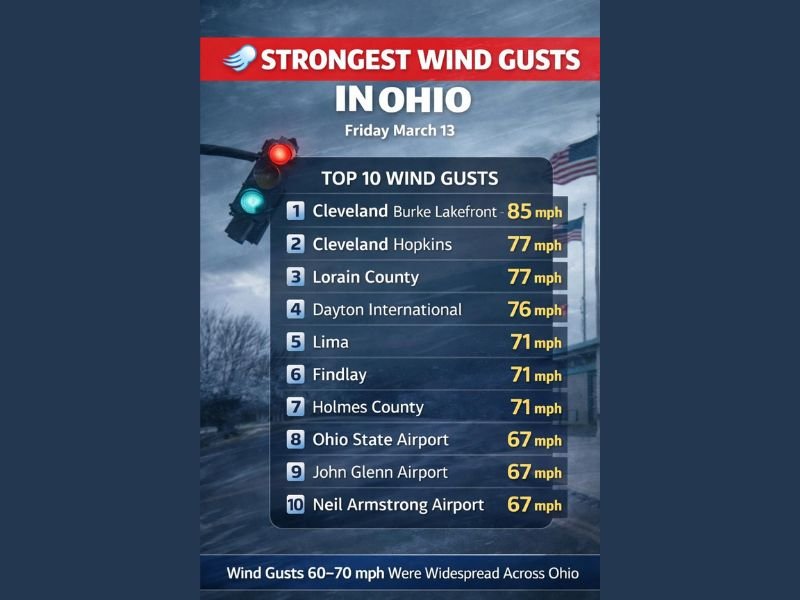
According to weather reports from the event, the highest wind gust recorded in Ohio occurred at Burke Lakefront Airport in Cleveland, where winds peaked at 85 mph. Another major observation came from Cleveland Hopkins International Airport, which reported a powerful 77 mph gust during the storm.
Strong winds were not limited to Cleveland, however. Several communities across Ohio experienced similarly intense gusts as the powerful system moved through the region.
Lorain County and Dayton Also Hit With Extreme Winds
Outside of Cleveland, other areas in northern and western Ohio also experienced damaging winds. Lorain County recorded a gust of 77 mph, matching the strong winds observed at Cleveland Hopkins Airport.
Further south, Dayton International Airport measured a 76 mph wind gust, highlighting the widespread nature of the storm. These wind speeds are strong enough to cause tree damage, power outages, and structural impacts in exposed areas.
Several Ohio Cities Saw Gusts Above 70 MPH
Multiple cities across Ohio also reported gusts exceeding 70 mph during the event.
Locations with recorded gusts around 71 mph included:
- Lima
- Findlay
- Holmes County
In central Ohio, both Ohio State Airport in Columbus and John Glenn Columbus International Airport measured wind gusts reaching 67 mph. Another 67 mph gust was reported at Neil Armstrong Airport in western Ohio.
Widespread 60–70 MPH Winds Across the State
Meteorologists say the windstorm produced powerful gusts across much of Ohio, with many locations experiencing sustained periods of winds between 60 and 70 miles per hour.
These winds were strong enough to create hazardous driving conditions, particularly for high-profile vehicles on highways and open roadways. Emergency crews across the state responded to reports of downed tree limbs, scattered power outages, and debris caused by the strong winds.
Cleanup Efforts Begin After Historic Wind Event
As the storm moves away, communities across Ohio are beginning cleanup efforts following the powerful wind event. Officials say damage assessments will continue in areas that experienced the strongest gusts, particularly across northern Ohio near Cleveland and along parts of Lake Erie.
Meteorologists say the storm stands out as one of the most notable wind events the state has seen in recent years, with unusually strong gusts recorded across multiple regions. Authorities are encouraging residents to remain cautious around damaged trees, power lines, and debris as recovery efforts continue following the powerful statewide windstorm.

I’ve lived in Naperville long enough to see how quickly our community changes — from new developments downtown to sudden shifts in our Midwest weather. Reporting on Naperville news and daily forecasts gives me the chance to keep neighbors informed about what really matters. My goal is simple: deliver clear, timely updates so you always know what’s happening in our city and what to expect from the skies above.