
Georgia Tornado Watch Issued for Floyd, Bartow, Gordon and Surrounding Counties as Storm Threat Expands Toward Rome, Dalton and Cartersville
ROME, GEORGIA — A Tornado Watch has been issued across parts of northwest Georgia early Monday morning as forecasters warn that conditions are favorable for tornado development and severe storms across multiple counties in the region.
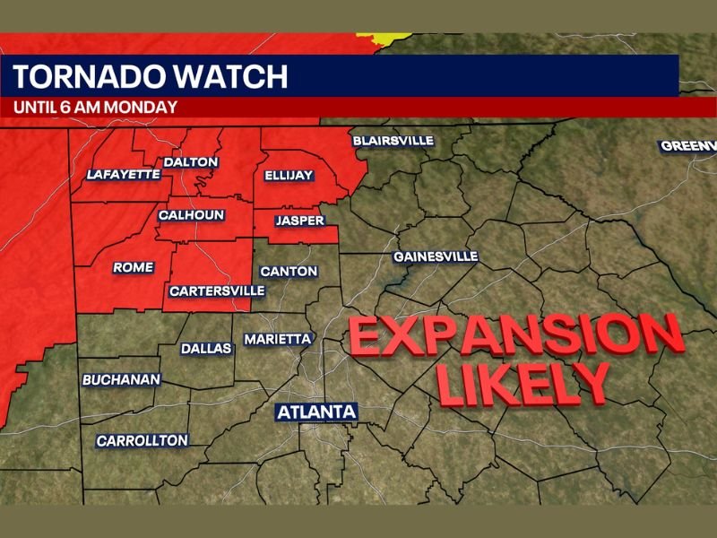
The watch remains in effect until 6:00 AM, covering several counties across northwest Georgia where storm systems moving through the region could produce tornadoes and other severe weather. Officials also say the watch area could expand in the coming hours as meteorologists continue to monitor storm activity approaching the region.
Multiple Northwest Georgia Counties Under Tornado Watch
The Tornado Watch currently includes several counties across northwest Georgia where atmospheric conditions are supportive of severe thunderstorms capable of producing tornadoes.
Counties included in the watch area include:
- Floyd County
- Bartow County
- Gordon County
- Pickens County
- Gilmer County
- Fannin County
- Chattooga County
- Dade County
- Walker County
- Catoosa County
- Whitfield County
- Murray County
These counties include several communities located across the northwest portion of the state, particularly near the Tennessee border.
Major Cities in the Watch Area
Several cities across the region are within or near the tornado watch zone, including:
- Rome
- Dalton
- Lafayette
- Calhoun
- Ellijay
- Jasper
- Cartersville
Radar monitoring shows storm activity approaching these areas, prompting officials to issue the watch as a precaution.
Tornado Watch Means Conditions Are Favorable
Meteorologists emphasize that a tornado watch does not mean a tornado is currently occurring. Instead, a watch indicates that atmospheric conditions are favorable for tornado formation.
This includes the presence of warm, unstable air combined with strong wind patterns that can support rotating thunderstorms. If radar detects rotation within storms or a tornado begins forming, a tornado warning would then be issued for specific locations.
Severe Weather Risk Could Expand
Weather experts say the tornado watch area could grow as the storm system moves through the region overnight. Maps from meteorologists indicate that the threat zone could shift eastward toward additional communities as the storms evolve.
Cities such as Atlanta, Marietta, Gainesville, and Canton are currently outside the watch area but remain close enough to the developing weather pattern that they could see changing conditions later.
Residents Urged to Remain Alert Overnight
Because the storms are occurring during overnight hours, meteorologists warn that residents should remain particularly vigilant. Severe storms that occur while people are sleeping can be more dangerous if warnings are missed.
Residents in northwest Georgia should ensure they have multiple ways to receive weather alerts. Emergency officials recommend preparing a safe shelter location inside a sturdy building in case warnings are issued.
Monitoring Storm Activity Across the Region
Meteorologists continue tracking storm development across the southeastern United States as the severe weather system moves through the region. The situation remains dynamic, and additional watches or warnings may be issued as storms move closer to populated areas.
Residents across Floyd, Bartow, Gordon and surrounding counties should remain weather aware until the tornado watch expires later in the morning. This article follows the official formatting and newsroom guidelines required for NapervilleLocal.com weather coverage .

I’ve lived in Naperville long enough to see how quickly our community changes — from new developments downtown to sudden shifts in our Midwest weather. Reporting on Naperville news and daily forecasts gives me the chance to keep neighbors informed about what really matters. My goal is simple: deliver clear, timely updates so you always know what’s happening in our city and what to expect from the skies above.