
This Weekend: Texas Faces Repeated Storm Chances With Heavy Rain Risk From Dallas-Fort Worth to Waco and Tyler
TEXAS — An unsettled weather pattern is expected to return this weekend, bringing multiple rounds of showers and thunderstorms across much of the state, especially impacting areas from Dallas-Fort Worth through Waco and into East Texas, with the potential for moderate to heavy rainfall and locally strong storms.
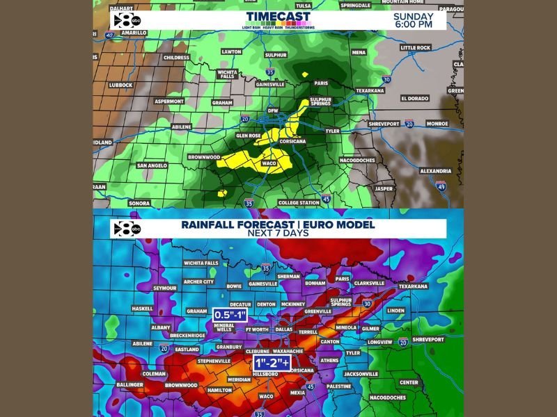
Storms Develop and Expand Across North and Central Texas
Forecast data shows widespread rain developing across North Texas, including areas around Dallas-Fort Worth, Gainesville, and Wichita Falls. Storm coverage is expected to increase as the weekend progresses, spreading into Central Texas cities like Waco, Corsicana, and surrounding regions.
Some storms could become strong at times, particularly as moisture continues to build and instability increases across the region.
Heaviest Rainfall Focuses South and East of Dallas
The most significant rainfall totals are expected along a corridor stretching from near Waco through Hillsboro, Corsicana, and into East Texas cities like Tyler and Sulphur Springs.
Rainfall projections indicate widespread totals of 1 to 2 inches or more, with locally higher amounts possible in the heaviest bands. Areas north and west of Dallas, including Mineral Wells and Decatur, may see lighter totals closer to 0.5 to 1 inch.
East Texas and Northeast Texas Remain in Active Zone
Communities across Northeast Texas, including Paris, Greenville, and Texarkana, are likely to remain in an active weather zone with repeated rounds of rain and embedded thunderstorms.
This repeated activity increases the risk of localized flooding, especially in areas where storms track over the same locations.
Timing and Impacts May Still Shift
While confidence is growing in a wetter pattern, the exact timing and intensity of storms could still change as the weekend approaches.
However, the overall setup clearly points toward an extended period of unsettled weather, with multiple opportunities for rainfall and occasional stronger storms. Stay with NapervilleLocal.com for the latest weather updates and local forecast coverage.

I’ve lived in Naperville long enough to see how quickly our community changes — from new developments downtown to sudden shifts in our Midwest weather. Reporting on Naperville news and daily forecasts gives me the chance to keep neighbors informed about what really matters. My goal is simple: deliver clear, timely updates so you always know what’s happening in our city and what to expect from the skies above.