
Scattered Thunderstorms With Gusty Winds to 50 MPH, Heavy Downpours, and Frequent Lightning Targeting the DFW Metroplex Including Dallas, Fort Worth, and Plano This Sunday
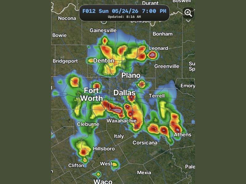
DALLAS-FORT WORTH METROPLEX — Scattered showers and thunderstorms are expected to develop across the DFW metroplex beginning around 3PM Sunday, May 24, 2026, driven by a leftover outflow boundary draped across the region and daytime heating through the afternoon. Future radar valid at 7PM shows widespread heavy storm coverage blanketing the entire metroplex from Denton and Gainesville through Dallas, Fort Worth, Plano, and southward through Waxahachie, Hillsboro, and toward Waco, with activity gradually fading after sunset.
Storms Developing Around 3PM and Expanding Through Early Evening Across the Metroplex
A leftover outflow boundary positioned across the metroplex this morning will combine with afternoon heating to spark scattered shower and thunderstorm development beginning around 3PM. Storm coverage will expand through the early evening hours before gradually weakening and fading after sunset as daytime heating diminishes.
The 3PM to 9PM window represents the primary impact period for the entire DFW region Sunday. Future radar initialized at 8:16AM and valid at 7PM Sunday shows intense red and yellow storm cores spread across a wide area from Denton southward through Dallas, Fort Worth, and Waxahachie.
Gusty Winds to 40 to 50 MPH and Frequent Lightning the Primary Hazards Sunday Afternoon
While storms are expected to remain non-severe in classification, stronger cells will be capable of producing gusty winds of 40 to 50 mph through the afternoon and evening hours. Frequent lightning will accompany the storm coverage across the entire metroplex, making outdoor exposure dangerous during the active window.
Heavy downpours capable of producing localized ponding on roadways and low-lying areas are also expected with the more intense cells tracking through the region. Residents with outdoor Memorial Day weekend plans should wrap up activities well before 3PM and remain indoors through the evening storm window.
Fort Worth, Waxahachie, and Athens Corridor Showing Heaviest Radar Cores at 7PM
The future radar depiction at 7PM shows the heaviest storm cores concentrated across the Fort Worth, Waxahachie, and Athens corridor, with intense red signatures indicating the most significant rainfall rates within those zones. Additional heavy cores are depicted near Denton, Plano, and Leonard to the north and northeast of the Dallas metro.
The broad coverage of heavy storm activity across the entire metroplex means very few communities within the DFW region will avoid impacts during the afternoon and evening window. Staying indoors, away from windows, and monitoring local alerts through the 3PM to 9PM period is the safest approach for all metroplex residents on Sunday. Stay with NapervilleLocal.com for the latest weather updates and local forecast coverage.

I’ve lived in Naperville long enough to see how quickly our community changes — from new developments downtown to sudden shifts in our Midwest weather. Reporting on Naperville news and daily forecasts gives me the chance to keep neighbors informed about what really matters. My goal is simple: deliver clear, timely updates so you always know what’s happening in our city and what to expect from the skies above.