
This Weekend: Texas and Oklahoma Face Expanding Severe Storm Threat Sunday With Hail, Damaging Winds, Tornado Risk, and Heavy Rain
TEXAS — A shift toward a more active weather pattern is expected this weekend, with storm chances increasing by Friday and a more organized severe weather threat developing by Sunday across Texas and Oklahoma, bringing risks of hail, strong winds, isolated tornadoes, and heavy rainfall.
Friday Brings First Round of Showers and Isolated Storms
Conditions will begin to change by Friday as the first disturbance moves into the region. While storms are expected to remain mostly non-severe, scattered showers and isolated thunderstorms could develop during the afternoon and evening.
With high moisture levels in place, even these weaker storms could produce quick downpours, briefly impacting travel and outdoor plans.
Saturday Storms Develop West and Shift East
By Saturday, the setup becomes more active as storms begin forming across West Texas and gradually move eastward.
Areas west of I-35 are more likely to see stronger storms during the day, while locations east of I-35, including Dallas-Fort Worth, may experience more scattered, non-severe thunderstorms into the evening hours.
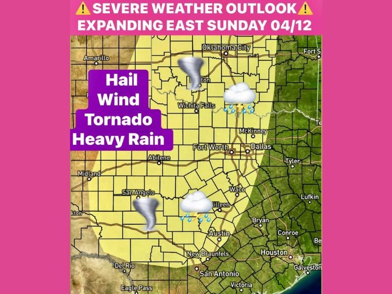
Sunday Severe Threat Expands Across the Region
The most significant concern arrives Sunday as the system strengthens and spreads east. The severe weather risk expands across much of Texas and into Oklahoma, including major cities such as Dallas, Fort Worth, Wichita Falls, Austin, and Oklahoma City.
All hazards are on the table, including large hail, damaging winds, isolated tornadoes, and heavy rain, especially into Sunday night as storms become more organized.
Heavy Rain and Flooding Risk Into Early Next Week
Along with severe storms, periods of heavy rainfall could lead to localized flooding concerns, particularly where storms repeat over the same areas.
The unsettled pattern is expected to continue into Monday, with another round of severe weather possible as the system moves across Texas and Oklahoma.
Active Pattern Continues Into Next Week
Looking ahead, much of next week is expected to remain active, with additional chances for showers and thunderstorms as the region works to make up for recent rainfall deficits.
While exact timing will continue to evolve, the overall trend points toward a wetter and more unsettled stretch of weather. Stay with NapervilleLocal.com for the latest weather updates and local forecast coverage.

I’ve lived in Naperville long enough to see how quickly our community changes — from new developments downtown to sudden shifts in our Midwest weather. Reporting on Naperville news and daily forecasts gives me the chance to keep neighbors informed about what really matters. My goal is simple: deliver clear, timely updates so you always know what’s happening in our city and what to expect from the skies above.