
Today: Michigan Sees Morning Rain, Gusty Winds, 60s South and 40s North With Late-Day Showers and Possible Snow Into Friday
MICHIGAN — A changing weather pattern is unfolding across the state today, starting with rain across southern Michigan before transitioning into partly cloudy conditions with isolated showers, gusty winds, and a sharp temperature split between warmer southern areas and cooler northern regions.
Morning Rain Impacts Southern Michigan Before Gradual Breaks
The day begins with rain across southern parts of the state, including areas around Detroit, Lansing, and Kalamazoo. This initial round of precipitation is expected to taper off through the morning hours.
However, conditions won’t stay completely dry, as another disturbance later in the day may bring additional showers back into parts of the region.
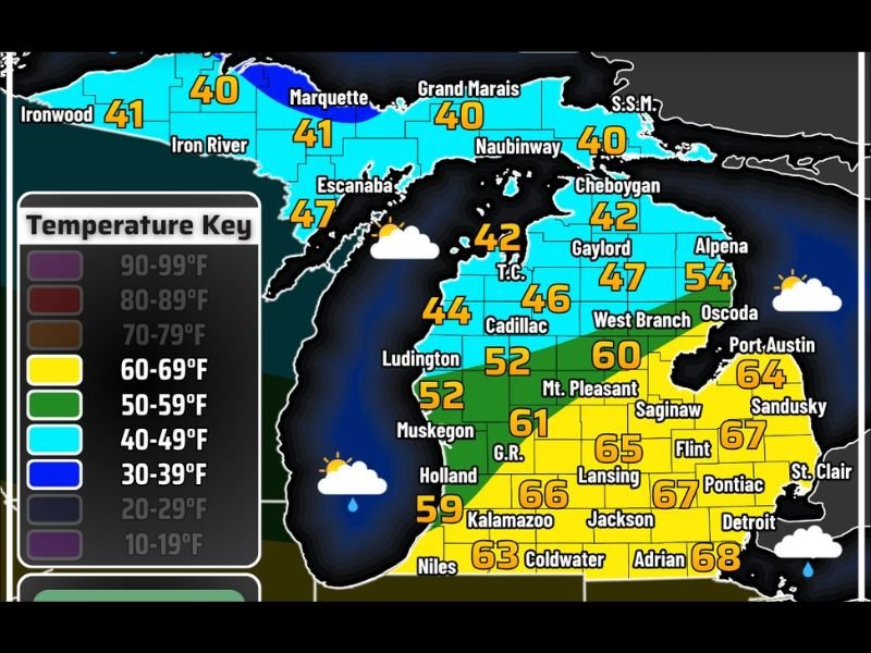
Warm South, Cool North Creates Temperature Divide
A noticeable temperature contrast is expected across Michigan today. Southern areas will warm into the mid to upper 60s, with some locations approaching the upper 60s by afternoon.
Meanwhile, northern Michigan will remain significantly cooler, with highs generally in the 40s, and even cooler conditions farther north toward the Upper Peninsula.
Gusty Winds Develop Across the State
Winds will become a factor throughout the day, with gusts reaching 20 to 30 mph at times.
These breezy conditions may make temperatures feel cooler, particularly in northern areas where colder air remains in place.
Isolated Showers Possible Later Today
As the second disturbance moves in later today and tonight, skies will turn partly cloudy with scattered showers developing across portions of the state.
Rain coverage will vary, meaning some areas may see additional precipitation while others remain mostly dry.
Late Night Mix Possible in Upper Peninsula
Later tonight, colder air moving into the region could allow for a light mix of precipitation across parts of the western Upper Peninsula.
This could include a mix of rain and snow, especially in areas where temperatures drop closer to freezing.
Snow Potential Returns by Friday Morning in Northern Areas
Looking ahead to Friday morning, temperatures falling below 32°F may allow for some light snow accumulation across parts of the northern Lower Peninsula.
While not expected to be widespread, this serves as a reminder that colder conditions are still possible in early spring. Stay with NapervilleLocal.com for the latest weather updates and local forecast coverage.

I’ve lived in Naperville long enough to see how quickly our community changes — from new developments downtown to sudden shifts in our Midwest weather. Reporting on Naperville news and daily forecasts gives me the chance to keep neighbors informed about what really matters. My goal is simple: deliver clear, timely updates so you always know what’s happening in our city and what to expect from the skies above.