
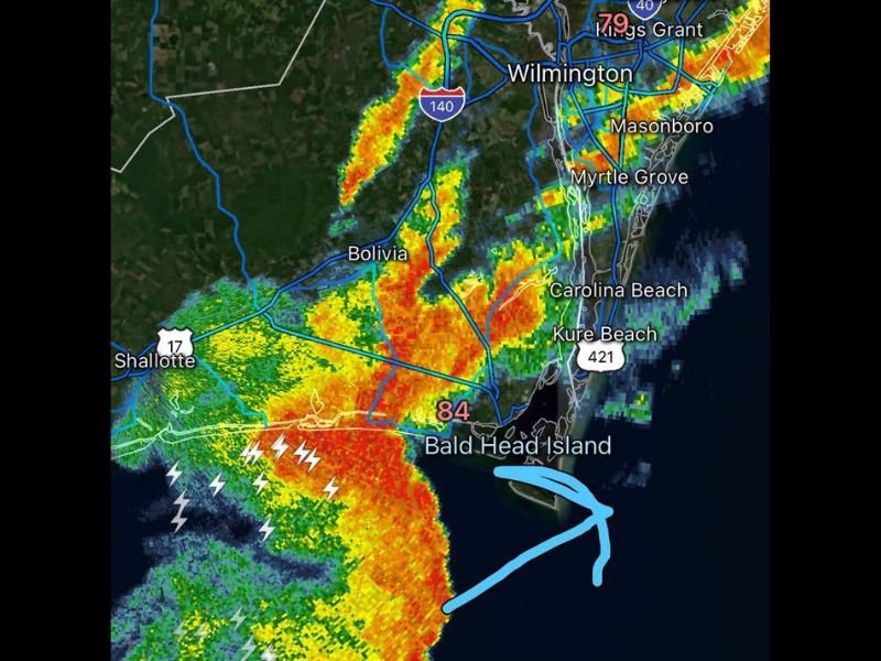
Burst of Very Heavy Rain and 40 to 50 MPH Wind Gusts Approaching Southern Brunswick County Including Shallotte and Bald Head Island This Morning
NORTH CAROLINA — A burst of very heavy rainfall is moving into Southern Brunswick County this morning, with wind gusts of 40 to 50 mph possible as the activity tracks through the area. The radar shows an intense line of storms with embedded lightning approaching from the southwest, targeting Shallotte, Bolivia, and the broader southern Brunswick County region as of 9:41 AM.
Intense Rainfall and Lightning Approaching Shallotte and Bolivia
The radar imagery shows a well-defined line of heavy storms with deep red and orange returns tracking across southern Brunswick County. Multiple lightning bolt icons are visible along the leading edge of the storm line near Shallotte and Highway 17, indicating active and frequent lightning accompanying this burst of heavy rain.
Bolivia, positioned directly in the path of this storm line, should expect very heavy rainfall and the potential for gusty winds as the activity continues to track northeastward through the morning.
Wind Gusts of 40 to 50 MPH Possible With This Burst
Beyond the heavy rainfall, wind gusts reaching 40 to 50 mph are possible as this storm system moves through Southern Brunswick County. Winds of this intensity can down tree limbs, create hazardous driving conditions, and lead to scattered power outages across the affected area.
Residents across the path of this storm should secure any loose outdoor items and avoid being outside as the heaviest rain and strongest winds move through.
Bald Head Island and Coastal Areas Also in the Path
The storm activity extends toward Bald Head Island and the surrounding coastal waters, with the radar showing the system’s motion continuing offshore to the northeast. Wilmington, Carolina Beach, and Kure Beach to the north are also seeing storm activity as the broader complex continues to evolve across the region.
Anyone in Southern Brunswick County should move indoors now if heavy rain and lightning have not yet arrived, and avoid travel until the burst of heavy weather passes through the area. Stay with NapervilleLocal.com for the latest weather updates and local forecast coverage.

I’ve lived in Naperville long enough to see how quickly our community changes — from new developments downtown to sudden shifts in our Midwest weather. Reporting on Naperville news and daily forecasts gives me the chance to keep neighbors informed about what really matters. My goal is simple: deliver clear, timely updates so you always know what’s happening in our city and what to expect from the skies above.