
Saturday: Sunny Start Gives Way to Clouds and Overnight Rain and Temperatures Reaching the Mid-to-Upper 50s With Some Southern Michigan Spots Pushing 60°F
MICHIGAN — Saturday across Michigan is shaping up to be a manageable and mostly pleasant day, with temperatures sitting comfortably in the 50s statewide and sunshine leading the way through the morning hours. While the day starts on a bright note, clouds will gradually build through the afternoon and evening, with rain moving in overnight — heaviest north of I-96 and across the Upper Peninsula.
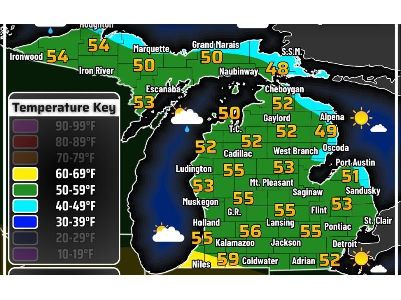
Temperatures Holding in the 50s Statewide
Readings across Michigan today are firmly in the 50s for the vast majority of the state, with the warmest numbers concentrated in the south. Niles leads the way at 59°F, followed by Kalamazoo at 56°F and Grand Rapids, Lansing, Ludington, and Muskegon all sitting at 55°F. Detroit and the southeastern corner are in the low-to-mid 50s as well.
Cooler conditions prevail across the Upper Peninsula, where Ironwood and Iron River are at 54°F, Escanaba at 53°F, and Marquette and Grand Marais at 50°F. The coldest spot in the state today is Houghton, sitting at just 43°F in the far north.
Southern Michigan Could Touch 60°F
With the sun angle continuing to climb higher in the sky as spring deepens, forecasters note it would not be surprising to see several locations across southern Michigan break the 60°F mark at some point during the afternoon.
Areas like Niles, Kalamazoo, and Coldwater are the most likely candidates to reach or exceed that threshold, particularly if skies manage to hold on to more sunshine through the early afternoon hours.
UV Index Jumps to Near 6 — Sunburn Possible
Despite the mild April temperatures, residents should not underestimate today’s sun. The UV index is forecast to climb to near 6, which is high enough to cause sunburn with prolonged unprotected exposure.
Anyone spending extended time outdoors — whether gardening, exercising, or simply enjoying the weekend — is advised to apply sunscreen and take appropriate precautions, even on what feels like a comfortable spring day.
Skies Turn Cloudy Into the Evening
The morning starts with sunny skies, but conditions will gradually deteriorate through the day. Sunshine gives way to mostly sunny conditions by midday, then partly cloudy skies push in through the afternoon and into the evening hours.
Winds will remain relatively calm throughout the day, keeping conditions comfortable despite the increasing cloud cover. However, winds are expected to pick up as the area heads into Sunday.
Overnight Rain Moves In — Heavier North of I-96 and the Upper Peninsula
The main weather concern for Saturday arrives after dark, as rain fills in overnight across the state. Precipitation will be heavier at times for areas north of I-96 and across much of the Upper Peninsula, where cloud cover and moisture are expected to be most concentrated.
Southern portions of the Lower Peninsula should see lighter activity, but residents statewide should plan for a wet end to the night. More weather graphics — including a wind map, severe weather outlook, and precipitation map — are expected to be released later today to help residents plan for the week ahead. Stay with NapervilleLocal.com for the latest weather updates and local forecast coverage.

I’ve lived in Naperville long enough to see how quickly our community changes — from new developments downtown to sudden shifts in our Midwest weather. Reporting on Naperville news and daily forecasts gives me the chance to keep neighbors informed about what really matters. My goal is simple: deliver clear, timely updates so you always know what’s happening in our city and what to expect from the skies above.