
This Week: Multi-Day Severe Weather Risk Sweeps From the Plains to the Great Lakes Through April 15 With Indiana, Chicago, St. Louis, and Detroit All in the Crosshairs
INDIANAPOLIS, Ind. — A significant and prolonged severe weather pattern is taking shape across a large stretch of the country, bringing multiple rounds of storm threats from the plains all the way through the Great Lakes region through April 15, 2026. Multiple storm systems will impact the area over the course of several days, with Indiana sitting directly in the path of the developing threat. Forecasters are urging residents across the affected zone to stay weather aware throughout the coming week.
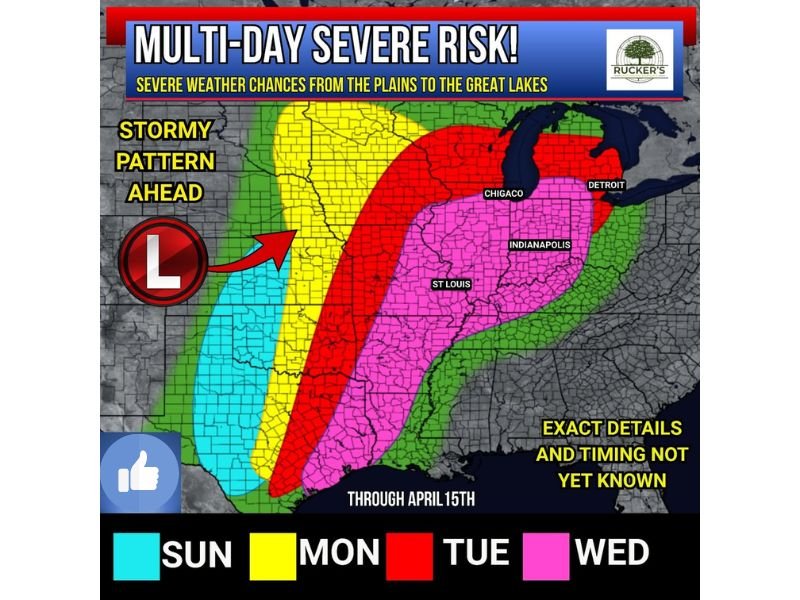
Stormy Pattern Builds Sunday Through Wednesday
The multi-day severe weather risk is broken down day by day, with each successive day bringing a different geographic footprint of storm coverage. A developing low pressure system is the primary driver of the pattern, pulling moisture and energy into the region and fueling multiple rounds of thunderstorm activity.
Sunday’s threat — shown in blue on the outlook map — is the most limited in scope, confined to a smaller area on the western edge of the risk zone. Monday’s risk expands significantly in yellow, covering a broader north-to-south corridor. Tuesday carries the most intense and widespread threat of the week, highlighted in red across a large swath stretching from the central plains through Chicago and Detroit. Wednesday’s risk shown in pink spreads across Indiana, St. Louis, and a wide portion of the Midwest and mid-South.
Tuesday Carries the Greatest Severe Weather Threat
Of all the days in the multi-day outlook, Tuesday stands out as the most concerning. The red zone on the outlook map covers an expansive area that includes Chicago, Detroit, Indianapolis, and a large portion of the surrounding region, indicating the highest level of organized severe weather potential in the current forecast.
The best chances for thunderstorms and the possibility of stronger, more dangerous storms are expected Tuesday onward. However, forecasters acknowledge there remains a decent amount of uncertainty around exact timing, storm forcing mechanisms, and the potential for a capped atmosphere that could limit or delay storm development.
Indiana Faces Severe Weather Chances Throughout the Week
Indiana is among the states most consistently in the threat zone across the entire multi-day period. From Sunday through Wednesday, portions of the state fall within at least one risk area on each day of the outlook, with the Tuesday through Wednesday window representing the peak concern for Hoosier communities.
Residents across Indiana — particularly in and around Indianapolis and communities to the north and west — should begin monitoring the forecast closely and making sure they have reliable ways to receive severe weather alerts throughout the week.
Exact Details and Timing Still Uncertain — Updates Expected
Forecasters are being transparent about the level of confidence in the current outlook. Exact details and timing are not yet fully known, and better forecast confidence is expected to develop as the week draws closer and weather models can better resolve the fine-scale details of each storm system.
The situation will be monitored continuously, and updated outlooks will be issued as new information becomes available. Residents should not wait until storms arrive to make a plan — now is the time to review safety procedures and stay tuned for incoming updates through April 15. Stay with NapervilleLocal.com for the latest weather updates and local forecast coverage.

I’ve lived in Naperville long enough to see how quickly our community changes — from new developments downtown to sudden shifts in our Midwest weather. Reporting on Naperville news and daily forecasts gives me the chance to keep neighbors informed about what really matters. My goal is simple: deliver clear, timely updates so you always know what’s happening in our city and what to expect from the skies above.