
Midwest and Central US Get a Well-Deserved Break From Severe Weather Sunday April 19 With No Severe Storms Expected Nationwide
MIDWEST AND CENTRAL UNITED STATES — A welcome and much-deserved break from severe weather has arrived for Sunday, April 19, 2026, as no severe weather is expected across the entire continental United States today. The quiet pattern comes as a significant relief particularly for residents across the Midwest, which has been the nation’s most active severe weather hot spot over the past several weeks and has endured a relentless series of tornado outbreaks, damaging wind events, and large hail episodes throughout April.
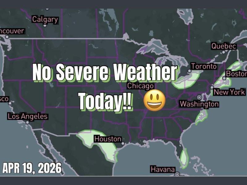
Nationwide Radar Shows No Severe Weather Threat Today
The April 19, 2026 outlook map confirms a completely clear severe weather picture from coast to coast. No severe thunderstorm watches, tornado watches, or significant convective threats are in place anywhere across the lower 48 states today, giving the entire nation a rare Sunday of quiet and calm weather conditions.
Only minor and non-severe shower activity is noted along portions of the Gulf Coast near Houston and Florida, and along isolated coastal zones in the Northeast. None of these areas carry any severe weather designation, and the activity is expected to remain well below severe thresholds throughout the day.
Midwest Gets the Break It Needed Most
Among all regions of the country, today’s severe weather break is most meaningful for the Midwest. Communities across northern Illinois, Wisconsin, Indiana, Ohio, Iowa, and surrounding states have faced repeated and intense severe weather outbreaks throughout April 2026, including the historic April 17 outbreak that produced over 150 tornado warnings across central Illinois alone and resulted in more than 25 confirmed tornado reports.
The opportunity to step back from the constant state of severe weather alert will allow residents, emergency managers, utility crews, and recovery teams across the region to assess damage, restore services, and regroup before the next round of severe weather potential returns later this week.
Brief Window Before Severe Weather Returns Thursday
While today’s break is genuinely welcome, residents across the southern Plains and Midwest should be aware that the reprieve is expected to be short-lived. Severe weather and tornado potential is already being flagged in long-range models for Thursday and Friday, with Kansas, Oklahoma, Nebraska, and Arkansas among the states currently in the crosshairs for the next significant outbreak threat.
The developing trough-ridge pattern across the country is expected to reignite severe weather activity across the southern Plains by the latter half of the week, with tornado potential specifically being highlighted through the end of April as peak storm season continues across the central United States.
Use Today to Prepare and Recover Before Next Week
With severe weather returning as early as Thursday, today’s quiet Sunday represents a valuable window for residents across the Midwest and southern Plains to use productively. Check and restock emergency supply kits, ensure weather alert apps and devices are functioning properly, review shelter plans with household members, and make any necessary repairs or preparations following last week’s damaging storms.
The break will not last long, but making the most of the calm period between active weather events is one of the most important preparedness steps any resident in a storm-prone region can take heading into the back half of April. Stay with NapervilleLocal.com for the latest weather updates and local forecast coverage.

I’ve lived in Naperville long enough to see how quickly our community changes — from new developments downtown to sudden shifts in our Midwest weather. Reporting on Naperville news and daily forecasts gives me the chance to keep neighbors informed about what really matters. My goal is simple: deliver clear, timely updates so you always know what’s happening in our city and what to expect from the skies above.