
Dangerous Heat Wave Building Across Colorado With Widespread 90s This Weekend and Near 100 Degrees Tuesday Through Thursday Across Denver
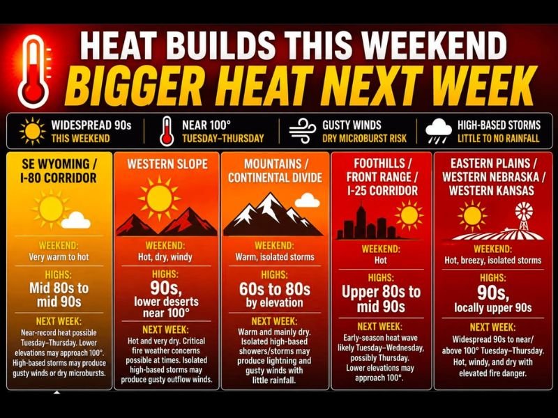
COLORADO AND SURROUNDING REGION — A strengthening ridge of high pressure is sending temperatures on a steady climb across Colorado and the surrounding region Saturday June 6th, with widespread 80s and 90s already in place this weekend before a more dangerous heat surge arrives Tuesday through Thursday. The bigger story is next week when widespread 90s and near 100 degree readings are expected across lower elevations from the Front Range through the eastern plains and western Nebraska.
High-based storms producing gusty dry microbursts and little to no rainfall will also be a concern throughout the heat event.
Widespread 90s This Weekend Before Near 100 Degree Heat Arrives Next Week
This weekend brings widespread 80s and 90s across most zones with the western slope reaching the 90s and lower desert locations approaching 100 degrees. The Front Range and I-25 corridor runs upper 80s to mid 90s Saturday and Sunday, while the eastern plains reach the 90s with locally upper 90s possible.
By Tuesday through Thursday, the heat intensifies significantly with near-record readings possible across lower elevations and some locations approaching or reaching 100 degrees.
Front Range Faces Early Season Heat Wave Tuesday Through Thursday
The Foothills, Front Range, and I-25 corridor are heading into an early season heat wave from Tuesday through Wednesday and possibly Thursday, with lower elevations potentially approaching 100 degrees during the peak of the event. The eastern plains into western Nebraska and western Kansas face widespread 90s to near or above 100 degrees Tuesday through Thursday with hot, windy, and dry conditions elevating fire danger significantly.
Critical fire weather concerns are possible at times across the western slope and plains during the peak heat window.
Dry Microburst Risk From High-Based Storms a Hidden Danger During Heat Event
High-based afternoon storms developing during the heat event will produce more wind than water, with dry microbursts and strong outflow winds possible while delivering little to no rainfall at the surface. Residents should stay hydrated, never leave children or pets in vehicles, check on elderly neighbors, and exercise extreme caution near lakes and reservoirs where cold water temperatures contrast dangerously with the extreme air temperatures.
Relief is expected to arrive late next week with cooler temperatures returning. Stay with NapervilleLocal.com for the latest weather updates and local forecast coverage.

I’ve lived in Naperville long enough to see how quickly our community changes — from new developments downtown to sudden shifts in our Midwest weather. Reporting on Naperville news and daily forecasts gives me the chance to keep neighbors informed about what really matters. My goal is simple: deliver clear, timely updates so you always know what’s happening in our city and what to expect from the skies above.