
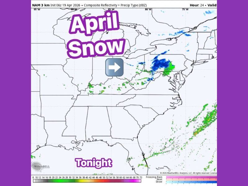
Rare April Snow Breaking Out Behind Cold Front Across West Virginia, Ohio, Pennsylvania, and New York Tonight in Uncommon Late Season Event
WEST VIRGINIA, OHIO, PENNSYLVANIA, AND NEW YORK — A rare and uncommon late-season snow event is unfolding tonight behind a departing cold front across a multi-state corridor stretching from West Virginia through Ohio and into Pennsylvania and New York. The NAM 3km model shows a well-defined swath of snow breaking out across the region tonight, with blue precipitation signatures indicating snow coverage across a surprisingly broad area for this late in the spring calendar.
Snow Breaking Out Across a Multi-State Corridor Tonight
Radar and model data for tonight shows snow developing and spreading from West Virginia northeastward through Ohio and into Pennsylvania and New York. The heaviest snow signatures on the NAM 3km composite reflectivity map are concentrated across western and central Pennsylvania, where the blue snow return is most intense and widespread.
The precipitation type transition from rain to snow is being driven by cold air sweeping in behind the departing front, with temperatures dropping quickly enough to support snow at lower elevations across portions of all four affected states.
Late April Snow Uncommon Across the Region
While snow in the mountains of West Virginia, Pennsylvania, and New York can technically occur into early May, a widespread snow event breaking out across lower elevation areas this late in April remains pretty uncommon. The combination of the cold frontal passage and the late April timing is what makes this event stand out from typical late-season mountain snow episodes.
The rarity of the event does not diminish its impact on residents across the affected areas who are likely expecting spring conditions rather than a return to wintry precipitation at this point in the season.
Cold Front Responsible for the Dramatic Pattern Shift
The snow event tonight is entirely tied to the cold front that swept through the region following the active severe weather period that dominated the eastern United States over the past several days. The front ushered in cold air rapidly enough to drop temperatures to snow-supporting levels across elevated terrain and portions of lower elevations across all four states.
The contrast between the tornado and severe thunderstorm activity of recent days and tonight’s April snow underscores just how dramatically weather patterns can shift across the eastern United States during the volatile spring transition season.
Slippery Roads Possible Overnight
Residents across the snow-affected corridor should be aware of potentially slippery road conditions tonight and through the early morning hours. Extra caution is advised for anyone traveling after dark across West Virginia, Ohio, Pennsylvania, and New York until temperatures rebound and snow coverage clears the region. Stay with NapervilleLocal.com for the latest weather updates and local forecast coverage.

I’ve lived in Naperville long enough to see how quickly our community changes — from new developments downtown to sudden shifts in our Midwest weather. Reporting on Naperville news and daily forecasts gives me the chance to keep neighbors informed about what really matters. My goal is simple: deliver clear, timely updates so you always know what’s happening in our city and what to expect from the skies above.