
Large Hail and Damaging Winds Targeting Oklahoma, North Texas, and Arkansas Saturday Late Afternoon Into Evening as Dryline and Frontal Boundary Move In
OKLAHOMA, NORTH TEXAS, AND ARKANSAS — The Storm Prediction Center has highlighted a Slight Risk for severe storms late afternoon into the evening hours this Saturday across a broad corridor covering Oklahoma, North Texas, and Arkansas.
A dryline pushing in from West Texas combined with a disturbance and frontal boundary will interact with strong instability and deep layer wind shear to support large hail and damaging winds with any storm that gets going as capping erodes through the afternoon. Saturday is also part of a three-day severe weather stretch with Friday and Sunday carrying similar setups across the region.
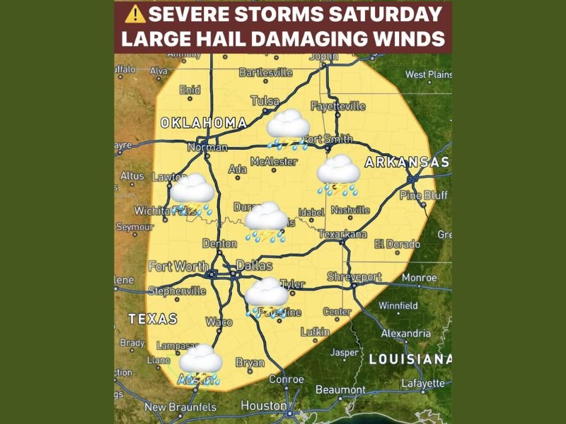
Slight Risk Zone Covers Oklahoma Through Houston Corridor
The Saturday severe weather risk map shows a large Slight Risk zone blanketing a wide swath of the south-central United States. The outlined area covers Oklahoma communities including Tulsa, Norman, Enid, Bartlesville, Ada, McAlester, and Lawton, extending southward through the Dallas and Fort Worth metro, Waco, Austin, and all the way down to Houston and Beaumont.
The risk zone also extends eastward across Arkansas including Fort Smith, Fayetteville, Texarkana, El Dorado, and Pine Bluff, while touching portions of Louisiana near Shreveport and Monroe. The broad geographic footprint means millions of residents across three states face at least some risk of encountering severe storms Saturday evening.
Dryline and Frontal Boundary Drive the Setup
The atmospheric trigger for Saturday’s severe weather potential is a dryline moving eastward from West Texas interacting with a disturbance and frontal boundary across the region. Strong instability and deep layer wind shear will be in place ahead of this boundary, creating favorable conditions for large hail and damaging winds with any storms that manage to break through the cap during the late afternoon hours.
The capping inversion suppressing storm development during the morning and midday hours is expected to erode as afternoon heating peaks, opening the door for storm initiation across the risk zone during the late afternoon and evening window.
Large Hail and Damaging Winds Are the Primary Threats
Two hazards stand out as the primary concerns with Saturday’s severe storm potential. Large hail capable of causing vehicle and property damage is supported by the strong instability and deep shear in place ahead of the dryline. Damaging wind gusts represent the second significant hazard, particularly as any storms that develop mature and potentially organize into more linear storm modes through the evening hours.
Three Consecutive Days of Similar Setup Through Sunday
Saturday’s threat does not stand alone but is part of a three-day severe weather stretch covering Friday, Saturday, and Sunday across the region. Each day carries a similar dryline-driven setup with comparable hazard profiles, meaning residents across Oklahoma, North Texas, and Arkansas should remain weather aware not just Saturday but through the entire weekend period. Stay with NapervilleLocal.com for the latest weather updates and local forecast coverage.

I’ve lived in Naperville long enough to see how quickly our community changes — from new developments downtown to sudden shifts in our Midwest weather. Reporting on Naperville news and daily forecasts gives me the chance to keep neighbors informed about what really matters. My goal is simple: deliver clear, timely updates so you always know what’s happening in our city and what to expect from the skies above.