
Cold Front Bringing Snow West of Continental Divide and Isolated Strong Thunderstorms to Eastern Colorado Plains Wednesday Before Cooler Pattern Takes Hold
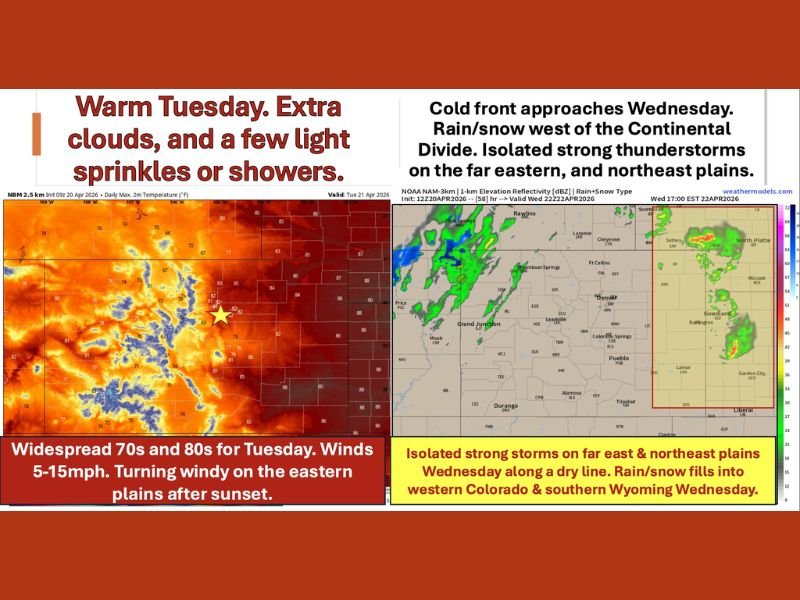
DENVER AND COLORADO FRONT RANGE — A warm and mostly dry Tuesday gives way to a significant pattern change beginning Wednesday as a cold front pushes into Colorado, bringing rain and mountain snow west of the Continental Divide and isolated strong thunderstorms capable of gusty winds, lightning, and hail along the dryline across the far eastern and northeast plains.
The pattern then turns progressively cooler and more active from Friday through the weekend and into next week with multiple chances for rain and snow across the region.
Warm Tuesday With 70s and 80s Before the Change Arrives
Tuesday April 21 brings widespread highs in the 70s and 80s across Denver and the Front Range with light winds of 5 to 15 MPH keeping conditions comfortable through the afternoon. A few extra clouds and light mountain sprinkles are possible but most areas east of the Divide stay dry through the day.
The eastern plains will turn notably windy after sunset as the low-level jet activates, producing gusts of 35 to 45 MPH through the overnight hours ahead of Wednesday’s cold frontal arrival.
Cold Front Triggers Snow and Thunderstorms Wednesday
Wednesday is when the pattern shifts meaningfully. Rain and high mountain snowfall develop west of the Continental Divide by afternoon into evening, with the northwest plateau potentially cold enough for snow late Wednesday night. Model data shows precipitation filling into western Colorado and southern Wyoming during the Wednesday afternoon and evening hours.
Along the dryline setting up across far eastern Colorado into Nebraska and western Kansas, isolated strong thunderstorms are possible with gusty winds, lightning, and hail. Winds will increase broadly across the region with strengthening southwest flow ahead of the front.
Cooler Temperatures Return Thursday Through Saturday
Behind the cold front, Thursday brings highs mainly in the 60s and 70s east of the Divide with snow showers across the central and northern mountains and mid 60s on the western slope. Friday maintains similar temperatures with precipitation chances beginning to increase as the pattern transitions toward a more active setup.
Saturday turns notably cooler with widespread 40s and 50s across the region, some 60s along Highway 50, and mid to upper 60s on the western slope ahead of a secondary cold front. Sunday becomes even cooler with an unsettled pattern continuing across Colorado.
Multiple Rain and Snow Chances From Friday Through Next Week
The bottom line for the extended forecast is an active and increasingly wet and snowy pattern developing from Friday onward through the weekend and into next week. Multiple chances for both rain and snow are expected across the region during this period, a welcome development for areas dealing with dry conditions heading into late April. Stay with NapervilleLocal.com for the latest weather updates and local forecast coverage.

I’ve lived in Naperville long enough to see how quickly our community changes — from new developments downtown to sudden shifts in our Midwest weather. Reporting on Naperville news and daily forecasts gives me the chance to keep neighbors informed about what really matters. My goal is simple: deliver clear, timely updates so you always know what’s happening in our city and what to expect from the skies above.