
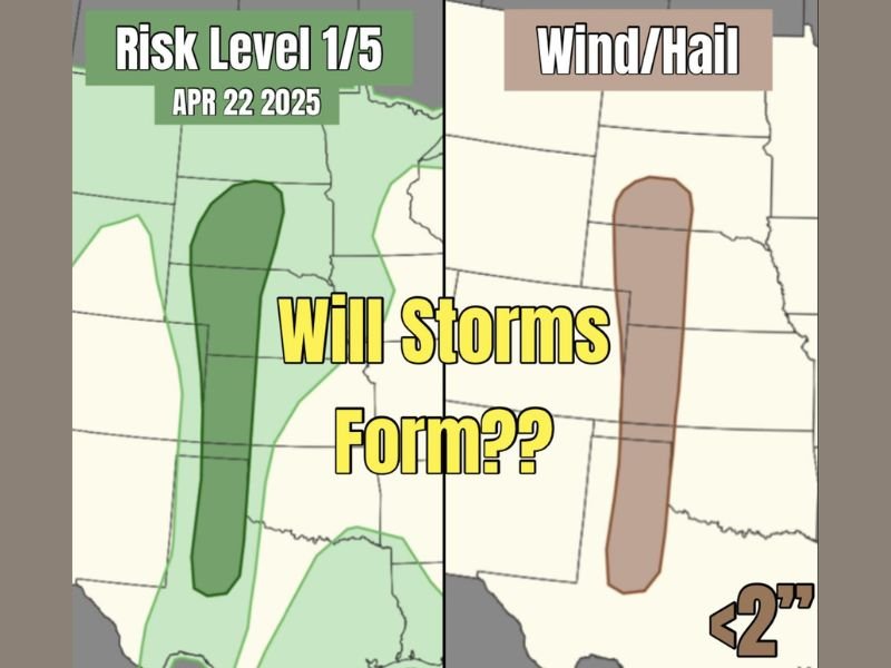
Conditional Supercell Threat Possible Across Central Nebraska Into Texas Panhandle Tuesday With Pocket Change Hail and Gusty Winds if Storms Manage to Form
CENTRAL NEBRASKA AND TEXAS PANHANDLE — A conditional and uncertain severe weather threat exists today across a corridor stretching from central Nebraska southward into the Texas Panhandle, but storm formation itself remains the biggest question mark.
Moisture is lacking and the cap is somewhat strong, meaning storms may not even develop despite wind profiles and atmospheric kinematics otherwise supporting supercell potential if initiation can occur. The Risk Level 1 out of 5 designation reflects the low confidence in storm development rather than the severity of any storms that do form.
Storm Formation Remains the Key Question Today
Unlike most severe weather setups where storm development is a near certainty, today’s situation hinges entirely on whether any storms can actually break through the strong capping inversion across the risk corridor. The lack of sufficient moisture combined with the moderately strong cap creates a significant barrier to storm initiation that may ultimately prevent any meaningful convective development across the outlined zone.
Wind profiles and kinematics in the atmosphere are otherwise supportive of supercell development, meaning that if even one storm manages to fire anywhere from central Nebraska into the Texas Panhandle, it would have a favorable environment to organize and intensify relatively quickly.
Pocket Change Hail and Gusty Winds Would Be the Primary Threats
If storms do manage to develop today, the primary hazards would be limited to pocket change size hail under 2 inches and gusty wind gusts with any supercells that form along the risk corridor. The wind and hail threat zone shown on the outlook map is concentrated across a narrow corridor through central Nebraska, consistent with where atmospheric conditions are most favorable for any storm initiation attempts.
Forecasters characterize today’s potential threat as not too significant compared to what is coming in the days ahead, with the real severe weather concern ramping up significantly starting tomorrow as the atmospheric pattern becomes much more favorable for organized storm development.
Bigger Severe Weather Threat Arrives Tomorrow
Today’s conditional and uncertain storm potential is essentially a prelude to a significantly more serious severe weather setup expected tomorrow. Forecasters are already flagging tomorrow as the day when the real severe weather action begins across the Plains, with a much more favorable atmospheric environment expected to support widespread and organized storm development compared to today’s marginal and uncertain setup.
Residents across central Nebraska and the Texas Panhandle should treat today’s threat as a low-end watch-and-see situation while preparing in earnest for the more significant threat that arrives tomorrow. Stay with NapervilleLocal.com for the latest weather updates and local forecast coverage.

I’ve lived in Naperville long enough to see how quickly our community changes — from new developments downtown to sudden shifts in our Midwest weather. Reporting on Naperville news and daily forecasts gives me the chance to keep neighbors informed about what really matters. My goal is simple: deliver clear, timely updates so you always know what’s happening in our city and what to expect from the skies above.