
Late Season Arctic Blast Targeting Midwest and Northeast Late April Into Early May With Highs in the 50s and Lows in the 30s Possible for Several Days
MIDWEST AND NORTHEAST — A late season arctic blast is on track to move through the Midwest and Northeast at the end of April into the beginning of May, bringing a dramatic cold air intrusion that will send temperatures plummeting well below seasonal norms for the time of year.
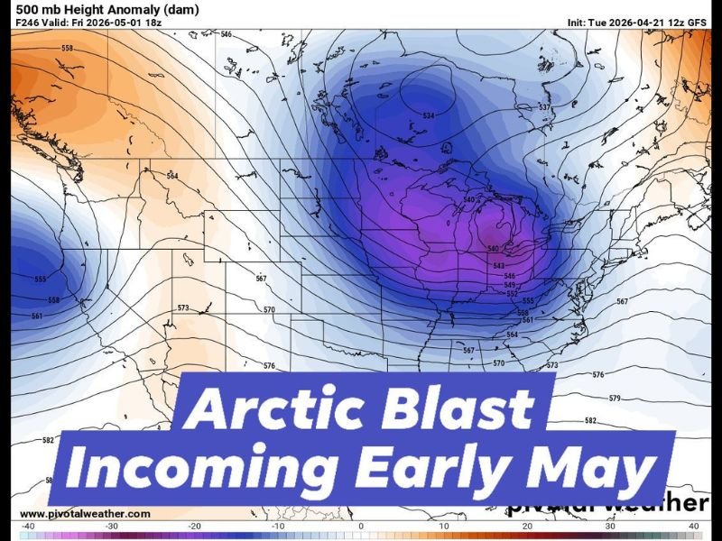
The GFS model 500mb height anomaly map valid Friday May 1, 2026 shows a deep and expansive pool of anomalously cold air centered directly over the Great Lakes and upper Midwest, with the cold anomaly extending broadly across much of the central and eastern United States. Highs in the 50s are possible for several consecutive days with overnight lows dropping into the 30s across the affected region.
Deep Cold Pool Centered Over Great Lakes and Upper Midwest
The 500mb height anomaly map initialized April 21, 2026 shows one of the more impressive cold air anomalies seen at this time of year, with the darkest blue and purple shading indicating extreme negative height anomalies centered directly over the Great Lakes and upper Midwest region. The cold pool extends southward into the Ohio Valley and eastward into the Northeast, covering an enormous geographic footprint across the central and eastern United States.
The depth and intensity of the cold anomaly shown on the GFS model is consistent with a late season arctic air mass that would be more typical of early to mid March rather than the late April and early May timeframe when it is expected to arrive.
Highs in the 50s and Lows in the 30s for Several Days
The temperature impacts from this late season arctic blast are expected to be significant and sustained rather than a brief one-day cold snap. Highs in the 50s are possible for several consecutive days across the Midwest and Northeast, representing temperatures that are 15 to 25 degrees below what would typically be expected for late April and early May across the region.
Overnight lows dropping into the 30s will bring frost and freeze concerns to a wide area during the coldest nights of the arctic blast period, particularly dangerous for gardens, landscaping, and agricultural crops that have already emerged and leafed out in response to the warm spring temperatures preceding the cold air arrival.
Late Season Timing Makes This Event Particularly Notable
The late April into early May timing of this arctic blast makes it a particularly notable and potentially impactful cold air intrusion. While cold snaps in late April are not unprecedented across the Midwest and Northeast, the depth of the cold anomaly shown on current model data suggests this event could be more significant than a typical late season cold spell in terms of both temperature departures and duration.
Residents across Illinois, Indiana, Ohio, Michigan, and surrounding Midwest and Northeast states should begin monitoring the forecast closely as the event approaches and take steps to protect sensitive vegetation before the cold air arrives. Stay with NapervilleLocal.com for the latest weather updates and local forecast coverage.

I’ve lived in Naperville long enough to see how quickly our community changes — from new developments downtown to sudden shifts in our Midwest weather. Reporting on Naperville news and daily forecasts gives me the chance to keep neighbors informed about what really matters. My goal is simple: deliver clear, timely updates so you always know what’s happening in our city and what to expect from the skies above.