
EF3+ Long-Track Tornadoes and Intense Tornado Outbreak Targeting Illinois Including Chicago, Peoria, and Springfield With Iowa and Missouri at Risk Monday Into Monday Night
ILLINOIS — A significant and potentially historic tornado outbreak is forecast across much of Illinois on Monday, April 27, 2026, beginning in the morning and lasting through the evening hours. The Storm Prediction Center has introduced a CIG2 designation for a large portion of the state, signaling a reasonable expectation for tornadoes of at least EF-3 intensity. Portions of Iowa and Missouri face elevated risk as well, with southern Wisconsin watching conditionally depending on how southward trends in surface features evolve.
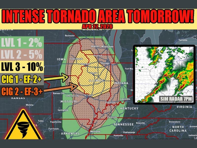
CIG2 Zone Signals EF-3 or Greater Tornado Potential Across Central and Southern Illinois
The SPC’s CIG2 designation — representing the highest ceiling of tornado intensity confidence — covers a substantial swath of Illinois. This level of designation is rare and reflects an environment capable of producing violent, long-track tornadoes that could cause catastrophic damage.
The atmosphere is described as a high-end parameter space, with supercell thunderstorms expected to fire during the morning hours and continue into the evening. Long-track tornado potential is among the primary concerns with this setup.
Level 3 Tornado Risk at 10 Percent Covering the Core of the Threat Zone
The tornado probability map places a Level 3 risk area at 10 percent covering the most volatile corridors of central and southern Illinois. A broader Level 2 hatched area at 5 percent and Level 1 at 2 percent extend outward across Iowa, Missouri, Indiana, and potentially southern Wisconsin.
A Level 4 MDT upgrade remains possible as forecast trends become clearer. This would elevate the event further into one of the more significant severe weather setups the region has seen in recent years.
Multiple Storm Rounds Expected From Morning Through Late Evening Hours
Storms are forecast to develop in multiple rounds throughout the day, creating a prolonged severe weather window that could last well into Monday night. Simulated radar imagery shows a complex of storms pushing through the region by approximately 7 PM local time.
The extended duration of the threat means residents should not assume the risk is over after the first wave. Each successive round carries potential for tornado-producing supercells, particularly while daytime heating and wind shear remain favorable.
Monday Plans Across Illinois and Surrounding States Require a Weather Safety Component
Anyone with outdoor activities, travel, or events planned for Monday across Illinois, Iowa, and Missouri should build a severe weather safety plan into their day. Identifying a sturdy shelter location and monitoring official alerts from the National Weather Service should be a top priority before storms arrive.
Residents are urged to have multiple ways to receive warnings, including a weather radio, smartphone alerts, and local broadcast coverage. Do not wait for a warning to begin seeking shelter if storms are approaching your area. Stay with NapervilleLocal.com for the latest weather updates and local forecast coverage.

I’ve lived in Naperville long enough to see how quickly our community changes — from new developments downtown to sudden shifts in our Midwest weather. Reporting on Naperville news and daily forecasts gives me the chance to keep neighbors informed about what really matters. My goal is simple: deliver clear, timely updates so you always know what’s happening in our city and what to expect from the skies above.