
Low Probability But Dangerous Severe Weather Possible Sunday Evening Across Western Arkansas Including Fort Smith and Mena With Large Hail and Tornado Threat
WESTERN ARKANSAS — A low-probability but potentially dangerous severe weather scenario is possible across western Arkansas this Sunday evening, April 26, 2026, between 5 PM and 10 PM local time. Confidence in storms even forming and impacting the region remains low, with most of the area expected to stay dry through the night. However, if one or two storms do develop, they could turn severe quickly, bringing large to very large hail and a tornado or two to communities near Fort Smith and Mena.
Low Confidence Setup But Storms Could Turn Severe Rapidly if They Develop
The overall forecast confidence for tonight’s potential is low, meaning most residents across Arkansas will see no storm activity at all. The key concern is the conditional nature of this threat — the atmosphere holds enough energy that any storm which does manage to form could intensify quickly and produce significant hazards without much lead time.
Forecasters are monitoring the situation closely as storm initiation remains uncertain. One or two isolated supercells are the primary storm mode of concern if convection does fire during the evening hours.
Large to Very Large Hail and a Tornado or Two Possible With Any Supercell That Forms
Should a supercell develop and track into western Arkansas, large to very large hail is the headline hazard alongside a tornado threat. These are not widespread or organized outbreak-level risks, but isolated supercells are capable of producing dangerous conditions very quickly and over a small geographic footprint.
The tornado potential is limited to one or two brief or isolated events, but any tornado in a populated area carries serious consequences. Residents in and around Fort Smith, Mena, and the surrounding western Arkansas corridor should remain weather-aware through the evening.
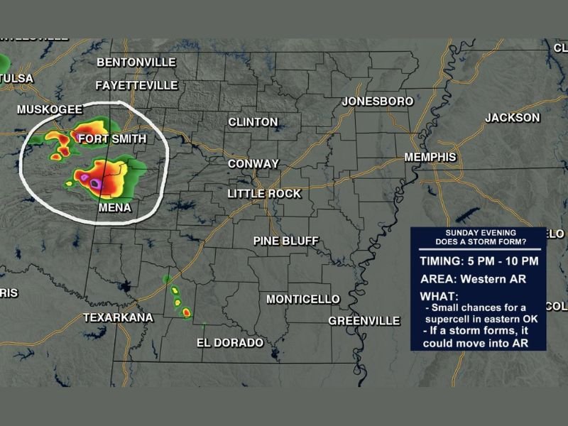
Primary Threat Window Runs From 5 PM to 10 PM Across Western Arkansas
The timing for any potential storm activity is focused between 5 PM and 10 PM this evening, making it an early-to-mid evening concern for western portions of the state. The futurecast model from Arkansas Weather Network shows storm activity circled near the Fort Smith and Mena area around 6:30 PM, giving a general picture of where the greatest risk would be concentrated if storms materialize.
Storms forming in eastern Oklahoma tonight and tracking eastward into Arkansas represent the most likely pathway for any severe threat to arrive. This Oklahoma-to-Arkansas track is the scenario forecasters are watching most closely.
Most of Arkansas Stays Dry Tonight But Western Corridor Should Remain Alert
The vast majority of Arkansas, including Little Rock, Jonesboro, Conway, and areas to the east, are not expected to see any storm activity tonight. This is a localized and conditional threat confined primarily to the western edge of the state near the Oklahoma border.
Despite the low probability, residents in western Arkansas should keep weather alerts active on their phones and be prepared to act quickly if a warning is issued. A fast-moving supercell can produce damaging conditions with limited warning time. Stay with NapervilleLocal.com for the latest weather updates and local forecast coverage.

I’ve lived in Naperville long enough to see how quickly our community changes — from new developments downtown to sudden shifts in our Midwest weather. Reporting on Naperville news and daily forecasts gives me the chance to keep neighbors informed about what really matters. My goal is simple: deliver clear, timely updates so you always know what’s happening in our city and what to expect from the skies above.