
Up to 3-Inch Hail, 70 MPH Winds, and Isolated Strong Tornadoes Targeting North Central Oklahoma Including Enid, Stillwater, and Bartlesville on Sunday With Enhanced Risk in Place
NORTH CENTRAL OKLAHOMA — A round of severe storms is possible across north central Oklahoma after 2 PM this Sunday, April 26, 2026, developing along a warm front and dryline pushing through the region. The greatest risk corridor stretches from just west of Enid through Stillwater to Bartlesville, where an Enhanced Risk is in place through 7 AM Monday morning. A conditional risk for fewer but potentially intense storms also exists farther south into the Oklahoma City metro, depending on exactly where storm boundaries set up during the afternoon.
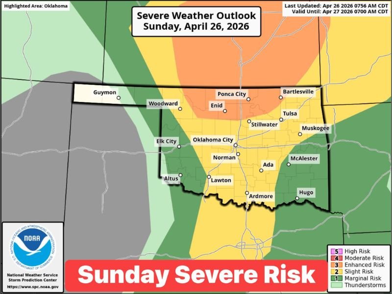
Enhanced Risk Corridor Runs From Enid Through Stillwater to Bartlesville This Afternoon
The core of today’s severe weather threat is concentrated across north central Oklahoma, where the Enhanced Risk zone covers communities including Enid, Ponca City, Stillwater, and Bartlesville. Storm placement along the warm front and dryline will be the determining factor in exactly which communities see the most significant activity this afternoon.
Most areas across Oklahoma will not see storms today, as storm initiation remains dependent on boundary placement. However, where storms do develop within the Enhanced zone, conditions are favorable for rapid intensification and multiple hazard types occurring simultaneously.
Up to 3-Inch Hail and 70 MPH Winds Headline the Hazard List for Today’s Storms
The primary threats with any supercell that develops this afternoon include hail up to 3 inches in diameter and wind gusts reaching 70 miles per hour. Hail of that size is capable of shattering windows, destroying vehicle surfaces, and causing serious roof damage within minutes of a storm’s passage.
Damaging winds at 70 MPH can down trees, snap power lines, and cause structural damage across a wide swath ahead of and alongside storm cores. Residents in the threat zone should move vehicles to covered parking and secure any outdoor items before afternoon storms approach.
Isolated Strong Tornadoes Possible Along Warm Front and Dryline Boundary
Isolated strong tornadoes are listed among the threats today, particularly where supercells can tap into the most favorable wind shear near the warm front and dryline intersection. The OKC metro faces a conditional tornado risk as well, depending on whether storm boundaries shift southward during the afternoon hours.
Tornado risk is not widespread today but should not be dismissed given the atmospheric ingredients in place. Any tornado that does develop could strengthen quickly, and residents across north central Oklahoma and the OKC metro should know their nearest shelter location before storms fire.
Afternoon Risk Area Could Still Shift as Boundary Placement Remains Uncertain
Storm initiation timing after 2 PM leaves several hours for the forecast to evolve, and the risk area could shift as the warm front and dryline move through the state. Communities currently sitting on the edge of the Enhanced and Slight Risk zones should treat this afternoon as an active weather situation regardless of current conditions outside.
Staying connected to weather updates throughout the afternoon is critical, as storm development can occur quickly once boundaries become established. Weather alerts should remain active on all devices for anyone in Oklahoma today. Stay with NapervilleLocal.com for the latest weather updates and local forecast coverage.

I’ve lived in Naperville long enough to see how quickly our community changes — from new developments downtown to sudden shifts in our Midwest weather. Reporting on Naperville news and daily forecasts gives me the chance to keep neighbors informed about what really matters. My goal is simple: deliver clear, timely updates so you always know what’s happening in our city and what to expect from the skies above.