
Severe Weather Risk Upgraded Across North Texas Including Dallas and Fort Worth With Large Hail, Damaging Winds, and Isolated Tornado Possible Between 4 and 6 PM Sunday
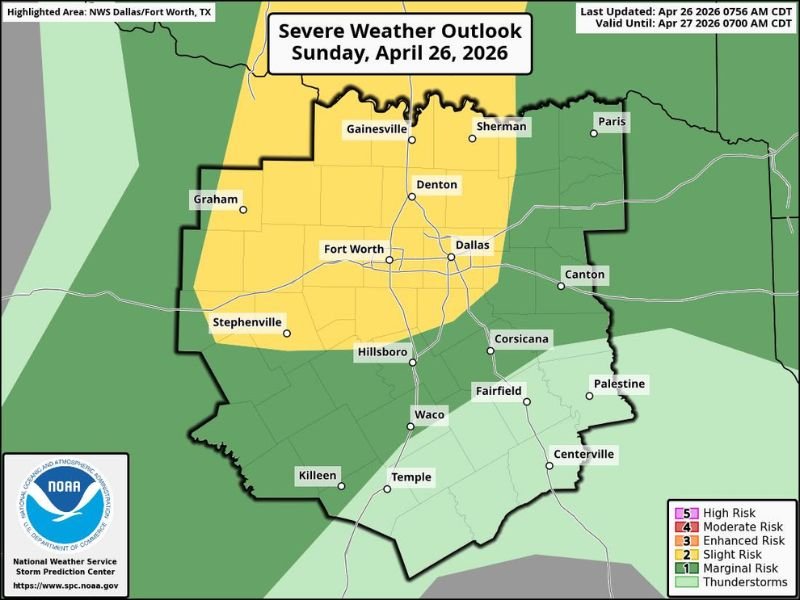
NORTH TEXAS — The Storm Prediction Center has upgraded and expanded the severe weather risk across North Texas today, Sunday, April 26, 2026, with a Slight Risk now covering a broad area including Dallas, Fort Worth, Denton, Gainesville, and Sherman.
Rogue supercells may initiate during the afternoon hours, carrying the potential for 2 to 4 inch hail, winds of 60 to 70 miles per hour, and an isolated tornado that could be strong given the storm energy in place. The primary window to watch is between 4 PM and 6 PM this afternoon.
SPC Expands Slight Risk Into North Texas as Rogue Supercells Possible This Afternoon
The SPC’s decision to expand the Slight Risk zone into North Texas reflects increasing confidence that one or two rogue supercells could fire later today despite a capping layer that has suppressed storm development through the morning hours. The Slight Risk area covers a large footprint from Graham and Stephenville in the west through the Dallas and Fort Worth metroplex eastward toward Canton and Corsicana.
Cap strength will be a key factor in determining whether storms actually develop this afternoon. Forecasters will be monitoring cap erosion throughout the day, and communities within the Slight Risk zone should treat the 4 PM to 6 PM window as the most critical period for potential severe weather.
Two to Four Inch Hail Is a Significant Threat With Any Supercell That Develops
Hail ranging from 2 to 4 inches in diameter is one of the primary hazards associated with any supercell that manages to fire this afternoon across North Texas. Hail at the upper end of that range is capable of causing catastrophic damage to vehicles, breaking windows, and punching through roofing materials within seconds of a storm’s arrival.
Residents across the Dallas, Fort Worth, Denton, and surrounding areas should move vehicles indoors or under covered parking before the afternoon threat window arrives. Waiting until storms are already approaching leaves little time to act given how rapidly supercells can produce large hail.
Isolated Strong Tornado and 60 to 70 MPH Winds Round Out the Hazard Profile
An isolated tornado is possible with any storm that develops, and forecasters note it could be strong given the atmospheric energy currently in place across the region. While tornado potential is not widespread today, a single strong tornado in a densely populated area like the Dallas-Fort Worth metroplex can cause significant damage and loss of life.
Wind gusts of 60 to 70 miles per hour are also expected with organized storm structures, capable of downing trees, snapping power lines, and causing property damage across a broad area. Residents should have a shelter plan ready and keep weather alerts active on their devices through the early evening hours. Stay with NapervilleLocal.com for the latest weather updates and local forecast coverage.

I’ve lived in Naperville long enough to see how quickly our community changes — from new developments downtown to sudden shifts in our Midwest weather. Reporting on Naperville news and daily forecasts gives me the chance to keep neighbors informed about what really matters. My goal is simple: deliver clear, timely updates so you always know what’s happening in our city and what to expect from the skies above.