
Scattered Showers Moving Through Central and Eastern North Carolina Including Raleigh, Greenville, and Wilmington Temporarily Reducing Wildfire Threat Through Mid Afternoon
CENTRAL AND EASTERN NORTH CAROLINA — Scattered showers are pushing through central and eastern sections of North Carolina this morning and into the early to mid afternoon hours, bringing light and spotty rainfall to communities including Raleigh, Greenville, Goldsboro, and Wilmington.
Total rainfall across the state is expected to range from near zero to around one inch, not enough to make a meaningful dent in ongoing drought conditions but sufficient to temporarily reduce the elevated wildfire threat that has persisted across the region. Temperatures across the affected areas are running in the low to mid 60s with cooler readings in the upper 50s farther north.
Rainfall Totals Expected Between Zero and One Inch Across Scattered Portions of the State
The scattered nature of today’s shower activity means rainfall totals will vary widely from one location to the next, with some areas seeing measurable rain while others nearby remain completely dry. Statewide totals are forecast to fall in the range of nearly zero to one inch, reflecting the hit-or-miss pattern typical of scattered shower and thunderstorm events.
While any rainfall is welcome given persistent drought conditions across much of North Carolina, today’s totals are not expected to provide meaningful drought relief for most locations. The rainfall does provide short-term improvement to soil moisture conditions in the areas that receive the higher end of totals.
Shower Activity Primarily Targeting Central and Eastern Sections Through Mid Afternoon
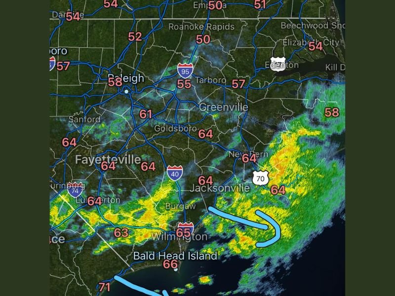
Radar imagery shows shower and storm activity concentrated across central and eastern North Carolina, with heavier cells visible near the Jacksonville, Wilmington, and coastal corridor. Activity is expected to continue pushing through the region through the early to mid afternoon before gradually diminishing.
Communities along the I-95 corridor including Roanoke Rapids and Tarboro are also seeing scattered activity, while areas farther west around Raleigh and Sanford are catching lighter coverage. Timing will vary by location depending on how individual cells track through the afternoon hours.
Wildfire Threat Temporarily Reduced Across the Region With Today’s Moisture
One of the more meaningful impacts of today’s shower activity is the temporary reduction in wildfire threat across North Carolina, which has faced elevated fire danger conditions in recent days. Even light and scattered rainfall helps raise relative humidity levels and dampen dry fuels that have made the landscape susceptible to rapid fire spread.
The wildfire threat reduction is expected to be short-term in nature, with drier conditions likely returning as the moisture moves out of the region. Residents in fire-prone areas should take advantage of today’s conditions but remain cautious about outdoor burning in the days ahead. Stay with NapervilleLocal.com for the latest weather updates and local forecast coverage.

I’ve lived in Naperville long enough to see how quickly our community changes — from new developments downtown to sudden shifts in our Midwest weather. Reporting on Naperville news and daily forecasts gives me the chance to keep neighbors informed about what really matters. My goal is simple: deliver clear, timely updates so you always know what’s happening in our city and what to expect from the skies above.