
Conditional Severe Weather Risk This Sunday Evening Across Oklahoma and North Texas Including Tulsa, Oklahoma City, and Bartlesville From 5 PM to Midnight
OKLAHOMA AND NORTH TEXAS — A conditional severe weather risk is in place across Oklahoma and North Texas this Sunday evening, April 26, 2026, with the main threat window running from 5 PM through midnight. A strong capping inversion has suppressed storm development through much of the day, but the cap may weaken enough after 5 PM to allow one or two isolated supercells to break through along the dryline to the west. The overall probability for an isolated severe storm is estimated at around 20 percent, keeping this a conditional but dangerous scenario.
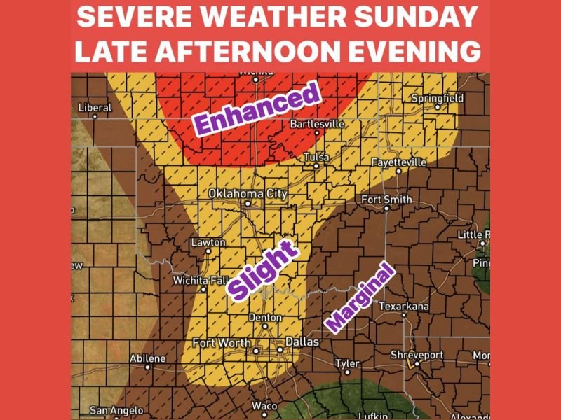
Enhanced Risk in Place Across North Central Oklahoma Including Wichita and Bartlesville
The highest risk on today’s outlook sits across north central Oklahoma, where an Enhanced Risk zone covers the area around Bartlesville and extends northward toward Wichita. This Enhanced corridor carries hatching indicating significant severe weather potential if storms manage to initiate and sustain themselves through the evening hours.
The dryline to the west is the focal point for any storm development, and forecasters are monitoring it closely for any signs of cap erosion after 5 PM. A single supercell breaking through in this zone could produce dangerous hazards rapidly, similar to storm activity observed in the region the previous day.
Slight Risk Extends South Through Oklahoma City, Lawton, and Into North Texas
A broad Slight Risk area extends southward from the Enhanced zone through Oklahoma City, Lawton, and Wichita Falls down into the Dallas and Fort Worth corridor. Communities including Denton, Fort Worth, and Dallas all fall within this Slight Risk footprint and should remain weather aware through the late evening hours.
The Slight Risk reflects lower storm initiation confidence farther south, where the cap is expected to remain stronger through the evening. However, any supercell tracking southward from the Enhanced zone could bring severe hazards into these areas with limited warning time.
Strong Capping Inversion Is the Key Variable Determining Tonight’s Storm Outcome
The strong capping inversion currently in place over North Texas and Oklahoma is the primary factor limiting storm development today. If the cap holds through midnight, most of the region will see little to no storm activity despite the favorable atmospheric energy available for severe weather.
The critical question is whether one or two spots along the dryline can break through after 5 PM. If that occurs, isolated supercells would have access to significant instability and wind shear, making any storm that does develop capable of producing large hail, damaging winds, and tornadoes. Stay with NapervilleLocal.com for the latest weather updates and local forecast coverage.

I’ve lived in Naperville long enough to see how quickly our community changes — from new developments downtown to sudden shifts in our Midwest weather. Reporting on Naperville news and daily forecasts gives me the chance to keep neighbors informed about what really matters. My goal is simple: deliver clear, timely updates so you always know what’s happening in our city and what to expect from the skies above.