
Two Major Impact Days Ahead for Alabama With Strong Storms Tuesday and Wednesday After a Quiet Sunday
ALABAMA — Today is the calm before a busy week across Alabama, with Sunday bringing mainly sunny skies and highs in the low 80s before a significant two-wave storm pattern arrives midweek. Tuesday and Wednesday are both flagged as Impact Days, with strong to severe thunderstorms expected to affect much of the state during both events. Rainfall totals through the week could reach 2 to 3 inches across portions of Alabama, though actual accumulations will be highly uneven depending on storm tracks.
Tuesday Is the First Impact Day With Strong Storms Returning Tuesday Evening
Monday brings partly cloudy and warm conditions with a 20 percent rain chance and strong storms possible after 10 PM as the first wave approaches overnight. Tuesday then becomes the first official Impact Day, with weakening storms lingering before sunrise from Monday night’s activity followed by a reload of rain and stronger thunderstorms returning Tuesday evening and overnight.
Highs on Tuesday will reach into the low 80s with an 80 percent rain chance, making it the highest-probability rainfall day of the week. Residents should prepare for a prolonged period of unsettled weather stretching from Monday night straight through Tuesday night.
Wednesday Brings the Second Impact Day With Early Storms and Gradual Clearing
Wednesday is flagged as the second Impact Day of the week, with lingering showers and storms pushing through before and after sunrise. Gradual clearing is expected through the late morning hours as the second wave exits the region, with highs near 80 degrees and a 70 percent rain chance.
The back-to-back Impact Days on Tuesday and Wednesday represent the core of this week’s rainfall opportunity for Alabama. These two waves are where the bulk of any significant accumulations will occur, though storm track shifts could leave some areas much wetter than others.
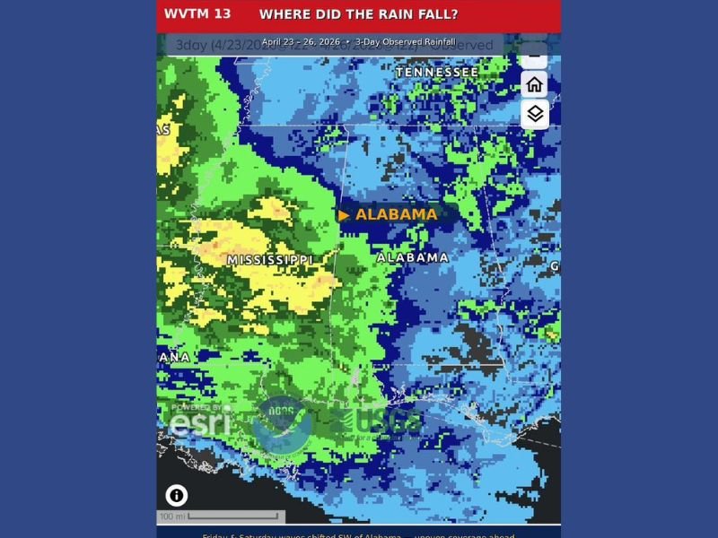
Weekend Storms Shifted Southwest Leaving Much of Alabama Drier Than Expected
The three-day observed rainfall map from April 23 through 26 shows the bulk of recent precipitation shifted southwest into Mississippi, leaving central and north Alabama considerably drier than forecast. The Tennessee Valley picked up significant rainfall in spots, but most of the state came up short as storm tracks deviated from original expectations.
This uneven pattern is a reminder that model rainfall estimates are projections, not guarantees. The WPC 7-day rainfall estimate showing 2 to 3 plus inches across Alabama is possible, but some communities will see substantial totals while others remain dry depending entirely on where storm bands set up.
Thursday Through Saturday Bring Spotty Showers as Pattern Slowly Improves
After the two impact days clear through Wednesday, the pattern gradually improves heading into the second half of the week. Thursday through Saturday bring spotty shower and storm chances each day as a slower and more unsettled pattern persists, with highs dropping from the upper 70s Thursday down to the upper 60s by Saturday.
Temperatures cool noticeably by the weekend with lows dropping into the low 50s by Saturday. The overall pattern through the week favors uneven rainfall distribution, and residents should not assume forecast totals will verify uniformly across the state. Stay with NapervilleLocal.com for the latest weather updates and local forecast coverage.

I’ve lived in Naperville long enough to see how quickly our community changes — from new developments downtown to sudden shifts in our Midwest weather. Reporting on Naperville news and daily forecasts gives me the chance to keep neighbors informed about what really matters. My goal is simple: deliver clear, timely updates so you always know what’s happening in our city and what to expect from the skies above.