
Heavy Rain of 1 to 3 Inches Expected Across the Southeast Including Alabama, Tennessee, and Georgia Tuesday Night Into Wednesday With a Second Round Friday Night
SOUTHEAST — A soaking rain event is on the way for a wide swath of the Southeast, with steady rainfall and embedded thunder expected to push through Tuesday night into Wednesday across Mississippi, Alabama, Tennessee, Georgia, South Carolina, and North Carolina. Rainfall totals of 1 to 3 inches are possible across the region, delivering much-needed moisture to areas that have been running dry in recent weeks. A second similar setup is also taking shape for Friday night into Saturday, offering back-to-back rainfall opportunities for the region.
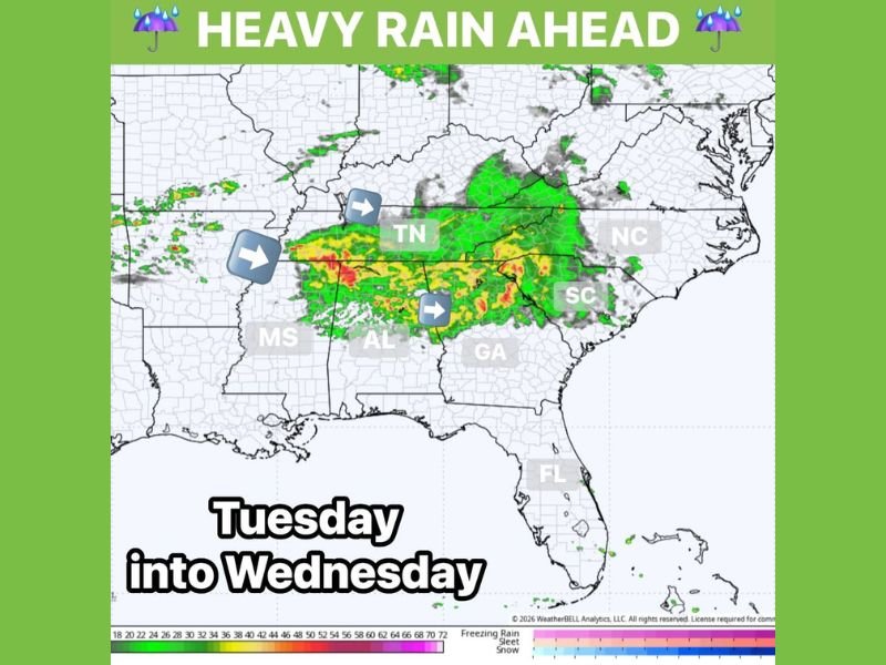
Steady Rain With Embedded Thunder Moves Through Tuesday Night Into Wednesday
The primary rainfall event arrives Tuesday night, bringing steady and persistent rain with embedded thunderstorms capable of producing locally heavy downpours. The rain is expected to continue through Wednesday morning and into the afternoon before gradually tapering off as the system pushes eastward through the region.
Radar imagery shows the heaviest rainfall corridor tracking across central Alabama, Tennessee, and into the Carolinas, with the deepest moisture values concentrated along this corridor. The steady and prolonged nature of this rainfall event is what sets it apart from typical hit-or-miss shower setups.
One to Three Inches of Rainfall Expected Across Areas That Need It Most
Total rainfall accumulations from the Tuesday night into Wednesday event are forecast at 1 to 3 inches across the core of the affected area, with the highest totals likely focused across Alabama, Tennessee, and northern Georgia. These amounts represent meaningful and beneficial rainfall for areas that have been dealing with dry conditions and elevated drought stress.
The rainfall map shows a concentrated band of heavier totals stretching from Mississippi eastward through Alabama and into the Carolinas, with lighter amounts on the northern and southern fringes of the system. Localized totals could exceed 3 inches where heavier training bands set up overnight.
Second Round of Heavy Rain Returns Friday Night Into Saturday
This week’s rainfall opportunity does not end with the Tuesday into Wednesday event, as a second similar setup is expected to develop Friday night into Saturday across the same general region. The back-to-back nature of these two systems represents exactly the kind of pattern needed to make a meaningful dent in drought conditions that have built up across the Southeast in recent weeks.
The Friday night round is expected to follow a comparable track and rainfall potential to the midweek event, though exact totals will become clearer as the week progresses. Residents across the affected states should be prepared for another round of steady and locally heavy rainfall heading into the weekend. Stay with NapervilleLocal.com for the latest weather updates and local forecast coverage.

I’ve lived in Naperville long enough to see how quickly our community changes — from new developments downtown to sudden shifts in our Midwest weather. Reporting on Naperville news and daily forecasts gives me the chance to keep neighbors informed about what really matters. My goal is simple: deliver clear, timely updates so you always know what’s happening in our city and what to expect from the skies above.