
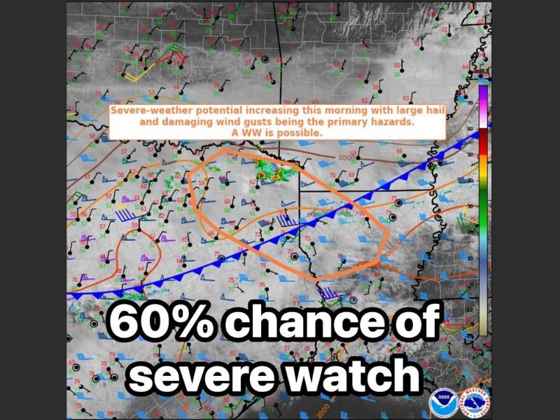
Large Hail Up to 3.5 Inches and 55 to 70 MPH Winds Threatening East Texas Including Tyler, Longview, and Greenville With 60 Percent Chance of Severe Watch Imminent
EAST TEXAS — The Storm Prediction Center is monitoring East Texas for a 60 percent chance of a Severe Thunderstorm Watch being issued in the near term, as severe weather potential increases rapidly across the region this Wednesday morning, April 29, 2026.
The watch area under consideration includes Greenville, Tyler, Longview, Mount Pleasant, Marshall, and Carthage. Primary hazards with any watch that is issued include large to very large hail measuring 2 to 3.5 inches, damaging wind gusts of 55 to 70 miles per hour, and tornado potential with winds up to 90 miles per hour identified in the SPC Mesoscale Discussion.
SPC Mesoscale Discussion 615 Flags 60 Percent Watch Probability Across East Texas
SPC Mesoscale Discussion number 615, valid until 12:15 PM CDT April 29, identifies a strongly unstable and weakly capped environment across far northeast Texas west of Texarkana as the primary driver of the elevated watch probability. A small cluster of elevated thunderstorms has persisted in the area this morning with recent intensification noted in several cells, signaling that conditions are ripening for organized severe storm development.
The 12z Fort Worth sounding sampled a MUCAPE environment of 3,000 to 3,500 joules per kilogram, reflecting an extremely unstable atmosphere capable of supporting intense supercell storm modes. Effective bulk shear magnitude of 60 or more knots is more than sufficient to support organized and persistent supercell development across the discussion area through the late morning hours.
Large to Very Large Hail Up to 3.5 Inches Is the Primary Hazard
The most probable peak hail intensity with today’s storms across East Texas is forecast at 2 to 3.5 inches in diameter, placing this event in the very large hail category capable of causing catastrophic damage to vehicles, roofs, and outdoor property. Hail at the upper end of this range can cause total loss vehicle damage and roof penetration within seconds of a storm’s passage over any given location.
Residents across the Tyler, Longview, Greenville, Mount Pleasant, and Marshall corridors should move all vehicles to covered parking immediately and avoid unnecessary travel as watch issuance becomes increasingly likely through the late morning hours. The combination of extreme instability and strong wind shear creates ideal conditions for prolific hail-producing supercells across this region.
Wind Gusts of 55 to 70 MPH and Tornado Potential Round Out the Hazard Profile
Damaging wind gusts of 55 to 70 miles per hour are listed alongside the hail threat as a primary hazard for East Texas today, with tornado winds up to 90 miles per hour also identified in the Mesoscale Discussion intensity parameters. The strong buoyancy and kinematic environment sampled this morning are more than supportive of supercell storm modes capable of producing all three hazard types simultaneously.
Residents across all communities within the potential watch area should have multiple ways to receive warnings active now and be prepared to take shelter immediately upon watch or warning issuance. The 60 percent watch probability and rapidly intensifying storm cluster indicate this situation could escalate very quickly through the midday hours. Stay with NapervilleLocal.com for the latest weather updates and local forecast coverage.

I’ve lived in Naperville long enough to see how quickly our community changes — from new developments downtown to sudden shifts in our Midwest weather. Reporting on Naperville news and daily forecasts gives me the chance to keep neighbors informed about what really matters. My goal is simple: deliver clear, timely updates so you always know what’s happening in our city and what to expect from the skies above.