
Cool and Breezy Tuesday Across Michigan Including Detroit, Grand Rapids, and the Upper Peninsula With Wind Gusts Up to 40 MPH and Highs in the 50s and 60s
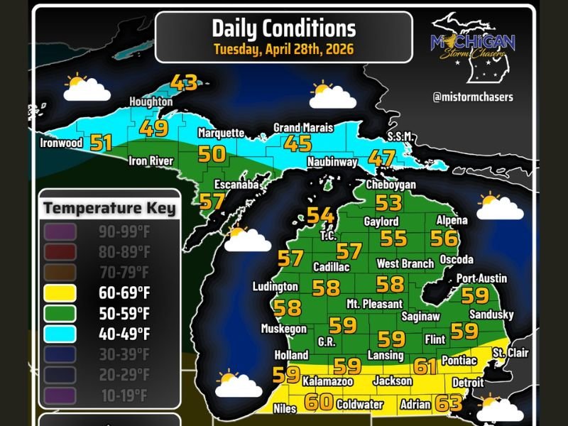
MICHIGAN — A cool and breezy Tuesday is in store across Michigan on April 28, 2026, with temperatures running a little on the cool side of average statewide following a busy Monday of storm chasing and wake low tracking across the region. High temperatures will reach the 60s south of Interstate 94 and stay in the 50s across most of the rest of the state, with the northern Upper Peninsula holding in the upper 40s and lower 50s through the afternoon. Skies will feature a mix of clouds and sunshine with a stray shower possible, particularly in the morning or very late tonight.
Highs in the 60s South of I-94 With the 50s Dominating the Rest of the State
Temperature readings across southern Michigan today will top out in the low to mid 60s, with Adrian reaching 63 degrees, Detroit and Pontiac in the low 60s, and communities including Kalamazoo, Jackson, Lansing, and Flint ranging from 59 to 61 degrees through the afternoon. This places much of the southern Lower Peninsula in a comfortable but noticeably cool range for late April.
Central and northern Lower Peninsula communities including Cadillac, Ludington, Muskegon, and Mt. Pleasant will see highs in the upper 50s today, while the Upper Peninsula ranges from the upper 50s near Escanaba southward down to the mid 40s near Grand Marais and Houghton in the far north. The statewide temperature pattern reflects a cool but seasonably reasonable April day across the region.
Wind Gusts of 20 to 30 MPH Statewide With 40 MPH Possible Along Lake Superior
Wind gusts of 20 to 30 miles per hour are possible across much of Michigan through approximately 8 PM EDT today, adding a breezy and at times gusty character to an otherwise manageable Tuesday. The strongest gusts will be concentrated across the Upper Peninsula, where winds exceeding 30 miles per hour are most likely and residents along the Lake Superior shoreline could see gusts reaching 40 miles per hour at times.
These wind speeds are not damaging by severe weather standards but are strong enough to create difficult conditions for high-profile vehicles, outdoor activities, and lake travel across the Upper Peninsula and northern Lower Peninsula corridors. Boaters and mariners along Lake Superior should use caution through the evening hours.
Stray Shower Possible This Morning and Late Tonight With Otherwise Mixed Sky Conditions
A stray shower cannot be completely ruled out across portions of Michigan, particularly during the morning hours and again very late tonight as the next weather system begins to approach the region. These shower chances are isolated and not expected to produce any significant rainfall accumulations across the state today.
Otherwise skies will feature a mix of clouds and sunshine through the afternoon hours, offering periods of pleasant conditions between cloud breaks. Michigan residents can expect a noticeably quieter weather day compared to Monday’s active severe weather and wake low event that impacted communities across the state. Stay with NapervilleLocal.com for the latest weather updates and local forecast coverage.

Naperville is a community with stories that deserve to be told — both the serious ones about safety and justice, and the lighter ones that capture our culture and daily life. I focus on covering crime reports and court updates while also highlighting the traditions, events, and social trends that shape who we are. Through my reporting, I want to give readers a fuller picture of Naperville — the challenges we face and the character that keeps our city strong.