
Steady Soaking Rain and Cool Northeast Winds Bring a Raw and Damp Saturday Before Drying Out Late Afternoon and a Sunshine Rebound Near 70 Sunday
NORTHEAST — A classic stratiform rain setup is taking shape for Saturday as a low pressure system pushes in from the south while cool northeast winds wedge in from the north, producing steady and soaking rain across the region through much of the day. This is not a storm event — no thunder, no severe weather — just a prolonged, damp, and cool rain that will hang over the area into the afternoon hours before gradually clearing. A strong rebound follows on Sunday with sunshine and highs climbing near 70 degrees.
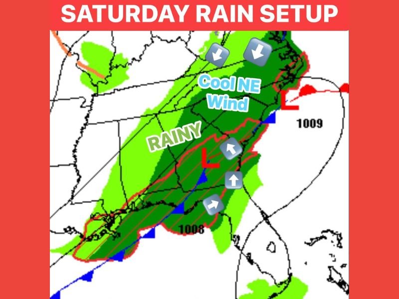
Low Pressure and Cool NE Wind Wedge Combine for All-Day Stratiform Rain Saturday
The collision of southerly moisture and cool northeast winds creates a textbook stratiform rain setup, delivering steady rainfall without the drama of thunderstorms. Southern portions of the affected zone are expected to see heavier rain totals given their closer proximity to the low pressure moisture source, while northern areas will trend toward lighter, mistier rainfall throughout the morning and midday hours.
Clouds will hang tough and skies will remain heavily overcast through much of Saturday, giving the day a raw and grey feel from start to finish. Temperatures will run cool all day, reinforcing the damp and uncomfortable character of the overall setup across the region.
Region Begins Drying Out Mid to Late Afternoon Just Ahead of Evening Plans
The best news in the Saturday forecast is the timing of the clearing trend, with conditions expected to begin drying out during the mid to late afternoon hours. This timing works in favor of anyone with Saturday evening plans, as the worst of the rain should be winding down before most outdoor or evening events get underway.
Temperatures heading into Saturday evening will fall into the 40s as skies clear, making it a chilly night even after the rain exits. Anyone attending outdoor evening events, including concerts or gatherings, is strongly advised to bring a jacket as the post-rain chill will be noticeable and persistent after dark.
Sunshine and Near 70 Degree Highs Return Sunday for a Full Weekend Recovery
Sunday delivers a complete turnaround from the raw and rainy Saturday, with sunshine returning and high temperatures climbing to near 70 degrees across the region. The bounce back will be swift and significant, offering a genuinely pleasant late weekend day after Saturday’s prolonged soaking rain event.
Residents should plan outdoor activities and any weekend errands for Sunday rather than Saturday to take full advantage of the dry, warm, and sunny conditions that follow the system’s departure. Stay with NapervilleLocal.com for the latest weather updates and local forecast coverage.

I’ve lived in Naperville long enough to see how quickly our community changes — from new developments downtown to sudden shifts in our Midwest weather. Reporting on Naperville news and daily forecasts gives me the chance to keep neighbors informed about what really matters. My goal is simple: deliver clear, timely updates so you always know what’s happening in our city and what to expect from the skies above.