
Supercells, Very Large Hail, Damaging Winds and Tornadoes Targeting Dallas Through Memphis Under Slight Risk Tuesday May 5 Afternoon and Evening
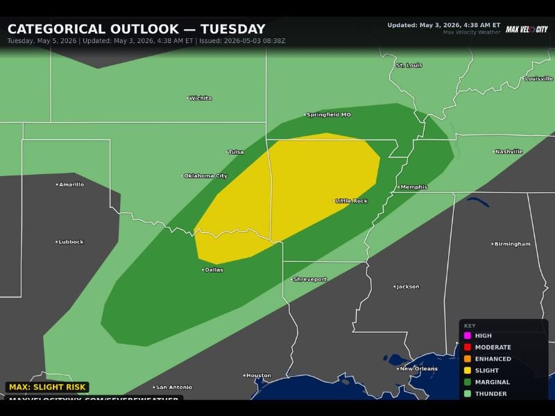
SOUTH CENTRAL — Supercell thunderstorms carrying very large hail, damaging winds, and a couple of tornadoes are possible across a broad corridor stretching from Dallas, Texas through Memphis, Tennessee on Tuesday, May 5, 2026. The categorical outlook updated at 4:38 AM ET on May 3 places the highest risk inside a Slight Risk zone covering Oklahoma City, Tulsa, Little Rock, and Memphis, with a broader Marginal Risk extending outward through Springfield Missouri, Shreveport, and surrounding states. Tuesday’s threat is primarily an afternoon and evening event.
Supercells With Very Large Hail and Damaging Winds Headline the Tuesday Slight Risk
The Slight Risk zone sits as a yellow-shaded core covering the Dallas to Memphis corridor, encompassing Oklahoma City, Tulsa, Little Rock, and the surrounding region as the highest confidence area for supercell development Tuesday afternoon. Very large hail and damaging winds are the primary and most likely hazards across this zone, with the atmospheric setup supporting discrete supercell storm mode capable of producing significant hail stones and destructive wind gusts.
The combination of instability and wind shear expected to be in place by Tuesday afternoon creates a favorable environment for organized and long-lived supercell development across the Slight Risk corridor throughout the peak heating hours.
Tornadoes Cannot Be Ruled Out Across Dallas to Memphis Corridor Tuesday Evening
Beyond hail and wind, a couple of tornadoes cannot be ruled out across the Dallas through Memphis risk zone, particularly during the afternoon and evening hours when storm organization reaches its peak. The supercell storm mode favored for Tuesday’s setup is the same mode most capable of producing tornadoes when atmospheric ingredients align correctly.
Residents across Oklahoma City, Tulsa, Little Rock, Memphis, and all communities within the Slight Risk zone should have weather alerts active and shelter plans ready well before Tuesday afternoon arrives.
Broader Marginal Risk Extends Through Springfield Missouri, Shreveport and Nashville
The wider Marginal Risk and general thunder zones extend broadly outward from the Slight Risk core, pulling Springfield Missouri, Shreveport, Nashville, and St. Louis into the overall severe weather picture for Tuesday. Communities across this broader zone face a lower but non-zero severe weather threat and should monitor forecast updates closely through Monday and into Tuesday morning. Stay with NapervilleLocal.com for the latest weather updates and local forecast coverage.

I’ve lived in Naperville long enough to see how quickly our community changes — from new developments downtown to sudden shifts in our Midwest weather. Reporting on Naperville news and daily forecasts gives me the chance to keep neighbors informed about what really matters. My goal is simple: deliver clear, timely updates so you always know what’s happening in our city and what to expect from the skies above.