
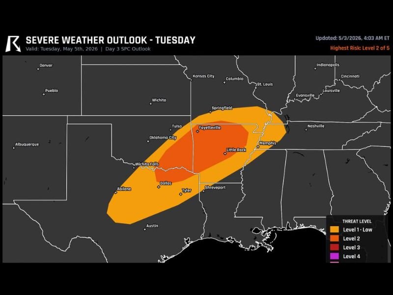
Large Hail, Damaging Winds and Tornadoes Likely Across Arkansas, Texas and Memphis Tuesday May 5 Evening Under Level 2 and Level 3 Severe Weather Outlook
SOUTH CENTRAL — Strong to severe storms are likely Tuesday evening, May 5, 2026, across a dangerous corridor stretching from north Texas through Arkansas and into the Memphis Tennessee area. The SPC Day 3 outlook updated at 4:03 AM ET on May 3 places the highest risk at Level 2 of 5, with a Level 3 core concentrated across Fayetteville, Little Rock, and the Arkansas River Valley corridor. Large hail, damaging winds, and a few tornadoes are all in play for Tuesday evening across the outlined risk zones. Residents are urged to identify safe shelter locations now and ensure weather alerts are active before Tuesday arrives.
Level 3 Core Targets Fayetteville, Little Rock and Arkansas River Valley Tuesday Evening
The highest confidence severe weather area on Tuesday is the darker red Level 3 core sitting directly over Fayetteville, Little Rock, and the Arkansas River Valley corridor stretching toward Memphis. This inner zone carries the greatest probability of significant severe weather, with all three primary hazards — large hail, damaging winds, and tornadoes — in play during the Tuesday evening hours.
The Level 3 designation reflects an elevated and meaningful threat that goes beyond a typical marginal or slight risk setup. Communities across central and northwest Arkansas and the Memphis metro should treat Tuesday evening as a serious weather event requiring advance preparation.
Level 2 Outer Zone Covers Dallas, Tyler, Shreveport and Springfield Missouri
The broader Level 2 orange zone extends outward from the Level 3 core, pulling Dallas, Wichita Falls, Tyler, Shreveport, and Springfield Missouri all into the Tuesday severe weather picture. This outer zone still carries a meaningful threat for large hail and damaging winds, with tornadoes remaining possible if storm organization reaches sufficient levels during the evening hours.
Communities across north and east Texas including Dallas and Tyler face a legitimate severe weather threat and should not discount their exposure based solely on sitting outside the highest risk core.
Residents Urged to Activate Alerts and Identify Safe Shelter Before Tuesday Evening
With strong to severe storms described as likely rather than just possible, Tuesday evening demands advance action from residents across the entire risk zone. Weather alerts should be activated on all devices immediately, and every household should identify and communicate their designated safe shelter location well ahead of Tuesday afternoon and evening storm development. Stay with NapervilleLocal.com for the latest weather updates and local forecast coverage.

I’ve lived in Naperville long enough to see how quickly our community changes — from new developments downtown to sudden shifts in our Midwest weather. Reporting on Naperville news and daily forecasts gives me the chance to keep neighbors informed about what really matters. My goal is simple: deliver clear, timely updates so you always know what’s happening in our city and what to expect from the skies above.