
Late Season Winter Storm Dumping 12 to 18 Inches Across Colorado Mountains With Denver Seeing Several Inches and Snow Spreading Into Wyoming, Nebraska and Kansas Through Wednesday
COLORADO — A remarkable late season winter storm is delivering significant snowfall across Colorado, Wyoming, Nebraska, and Kansas through Wednesday, May 6, 2026. The mountains could receive more than a foot of snow, with some higher elevation areas seeing 12 to 18 inches. Snow has begun falling in Denver this evening and the city could see a few inches — potentially more than it received in October, November, and February combined. It is May, making this one of the most unusual late season snow events in recent memory.
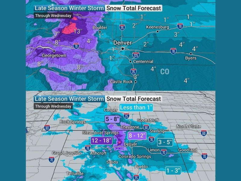
Mountains Picking Up 12 to 18 Inches With 13 Inches Already Recorded at Higher Elevations
The highest snow totals are concentrated across the Colorado mountains, where 12 to 18 inch accumulations are forecast through Wednesday. Isolated pink zones on snow total mapping are already showing 13 inch readings at the highest elevations west of Boulder and Georgetown.
Georgetown, Steamboat Springs, and surrounding mountain communities are sitting inside the 8 inch plus zones. Ashcroft and the central mountains are carrying the deepest purple 12 to 18 inch forecast corridor through the event.
Denver Picking Up Several Inches With Cheyenne Seeing 8 to 12 Inches Through Wednesday
Denver is forecast to receive 1 to 2 inches across the metro area with some southern and eastern suburbs like Castle Rock and Centennial picking up 3 to 4 inches. The I-25 corridor between Denver and Cheyenne sits inside the 8 to 12 inch zone, making travel along that corridor extremely hazardous through Wednesday.
Boulder sits at 1 inch on current maps but higher terrain nearby is tracking significantly more. Keenesberg, Byers, and eastern plains communities are looking at 1 to 4 inches through the event.
Snow Spreading Into Wyoming, Nebraska and Kansas With 5 to 8 Inches Near Cheyenne
The storm extends well beyond Colorado, with Cheyenne tracking 5 to 8 inches and Rock Springs seeing similar totals across Wyoming. Sterling and surrounding northeast Colorado communities are forecast at 3 to 5 inches, with 1 to 3 inches reaching into western Kansas near Goodland and Liberal. Stay with NapervilleLocal.com for the latest weather updates and local forecast coverage.

I’ve lived in Naperville long enough to see how quickly our community changes — from new developments downtown to sudden shifts in our Midwest weather. Reporting on Naperville news and daily forecasts gives me the chance to keep neighbors informed about what really matters. My goal is simple: deliver clear, timely updates so you always know what’s happening in our city and what to expect from the skies above.