
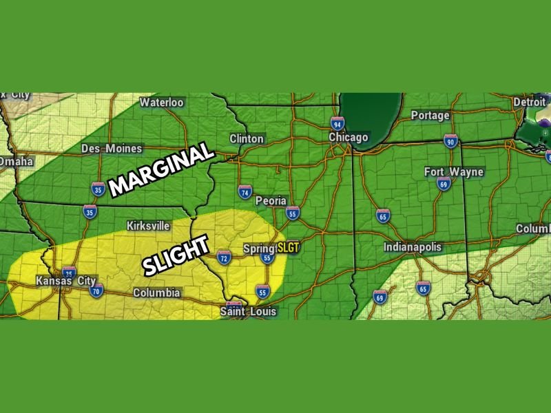
Large Hail and Gusty Winds Targeting Chicago, Peoria and Clinton Under Marginal Risk With Slight Risk Pushing Into Springfield and St. Louis This Afternoon Between 3PM and 9PM
ILLINOIS — The Storm Prediction Center has upgraded today’s severe weather outlook by introducing a Level 2 Slight Risk well to the south of the Illinois stateline, while a Level 1 Marginal Risk continues for the Chicago, Peoria, and Clinton corridor this afternoon and evening, Monday May 4, 2026. Isolated to scattered thunderstorms are expected to develop between 3 PM and 5 PM and move through the region by roughly 9 PM. Large hail and gusty winds are the primary hazards, with tornado risk remaining very low across the Marginal Risk zone.
Marginal Risk Covers Chicago Through Peoria and Clinton Between 3PM and 9PM
The Level 1 Marginal Risk zone covers a broad area across Illinois including Chicago, Waterloo, Clinton, and Peoria through this afternoon and evening. Isolated to scattered thunderstorm development is expected during the 3 to 5 PM window with storms moving through by approximately 9 PM.
Gusty winds and large hail headline the hazard list for the Marginal Risk zone. Tornado risk is described as generally low and not a primary concern for communities sitting inside this northern Illinois corridor.
Slight Risk Sits Well South of the Stateline Across Springfield and St. Louis Zone
The upgraded Level 2 Slight Risk zone introduced by the Storm Prediction Center this morning sits well south of the Illinois stateline, covering Springfield, St. Louis, Columbia, Kirksville, and Kansas City. This southern zone carries a higher severe weather probability than the Marginal Risk area to the north.
Communities across the Slight Risk zone face a more meaningful threat for organized severe storm development, with large hail and damaging winds the dominant hazards through the afternoon and evening hours.
Tornado Threat Remains Very Low Across Both Risk Zones Today
Forecasters are expressing low concern about tornado development across both the Marginal and Slight Risk zones today. The severe weather focus remains squarely on gusty winds and large hail as the primary threats through the 3 PM to 9 PM window across Illinois and Missouri. Stay with NapervilleLocal.com for the latest weather updates and local forecast coverage.

I’ve lived in Naperville long enough to see how quickly our community changes — from new developments downtown to sudden shifts in our Midwest weather. Reporting on Naperville news and daily forecasts gives me the chance to keep neighbors informed about what really matters. My goal is simple: deliver clear, timely updates so you always know what’s happening in our city and what to expect from the skies above.