
Severe Weather Ramping Up Across Louisiana, Arkansas, Mississippi and Alabama Wednesday May 6 With Slight Risk Covering Birmingham, Jackson and Memphis Through Early Thursday
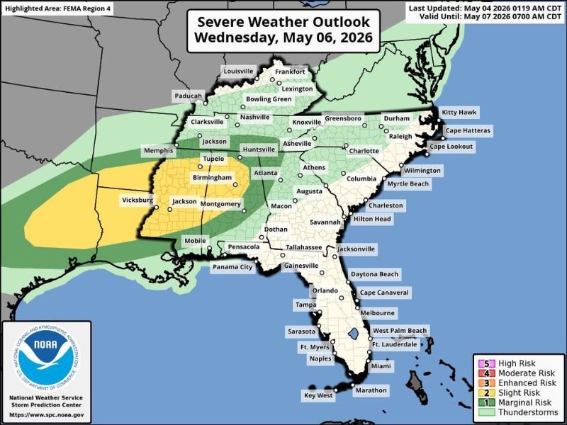
THE SOUTH — Severe weather risks are ramping up significantly across the South on Wednesday, May 6, 2026, with the primary threat zone covering Louisiana, Arkansas, Mississippi, and Alabama through early Thursday morning. The SPC outlook valid until May 7 places a Slight Risk yellow zone across Birmingham, Jackson, Tupelo, Vicksburg, and Memphis, with a broader Marginal Risk extending into Tennessee, Georgia, and the Carolinas. Rain and thunderstorms are expected to continue into Thursday morning across the entire affected region.
Slight Risk Targets Louisiana, Arkansas, Mississippi and Alabama Wednesday
The highest confidence severe weather zone sits across a yellow Slight Risk corridor covering Jackson Mississippi, Vicksburg, Tupelo, Birmingham, Montgomery, and Mobile through Wednesday. Memphis sits on the northwestern edge of the Slight Risk zone as well.
This corridor represents the greatest organized severe weather threat of the event, with damaging winds, large hail, and tornadoes all possible across the Slight Risk area during Wednesday’s active weather window.
Marginal Risk Extends Into Tennessee, Atlanta, Nashville and the Carolinas
The broader Marginal Risk green zone pulls Nashville, Clarksville, Huntsville, Atlanta, Macon, Augusta, Charlotte, and Raleigh all into the Wednesday severe weather picture. Communities across this zone face lower but meaningful severe weather potential through the day and into the overnight hours.
Early Thursday morning timing for the Carolinas and Georgia helps limit the most intense severe weather potential for those states while still delivering beneficial rainfall across the region.
Rain and Thunderstorms Continue Into Early Thursday Across the Entire South
The overall system delivers rain and thunderstorm coverage well beyond just the highest risk zones, with general thunderstorm activity reaching from Memphis through the entire Southeast into the Carolinas and coastal communities. Jacksonville, Tallahassee, Savannah, Charleston, and Wilmington all fall inside the general thunderstorm coverage zone through the Wednesday night into Thursday morning window.
Residents across Louisiana, Arkansas, Mississippi, and Alabama should have weather alerts active and shelter plans ready well ahead of Wednesday afternoon and evening storm development. Stay with NapervilleLocal.com for the latest weather updates and local forecast coverage.

I’ve lived in Naperville long enough to see how quickly our community changes — from new developments downtown to sudden shifts in our Midwest weather. Reporting on Naperville news and daily forecasts gives me the chance to keep neighbors informed about what really matters. My goal is simple: deliver clear, timely updates so you always know what’s happening in our city and what to expect from the skies above.