
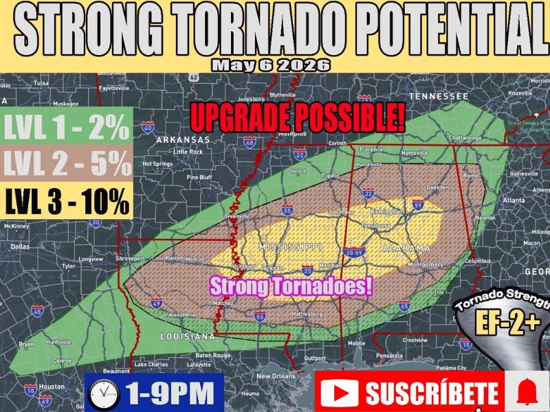
EF-2 Plus Tornadoes and Supercells Targeting Mississippi and Alabama Including Jackson, Meridian and Tuscaloosa Wednesday 1PM to 9PM With Level 4 Upgrade Possible
MISSISSIPPI AND ALABAMA — A dangerous and potentially very active severe weather day is unfolding across Mississippi and Alabama on Wednesday, May 6, 2026, with strong tornado potential rated at EF-2 and above across the primary risk zone. A powerful jet streak combined with very strong mid-spring instability will fuel supercell development beginning as early as 1 PM and persisting through 9 PM. A Level 3 ten percent tornado probability currently covers the core risk zone, with a Level 4 upgrade possible if skies clear and big-time instability is fully realized through the afternoon.
EF-2 Plus Tornado Threat Active Across Mississippi and Alabama From 1PM to 9PM
The highest risk hatched zone covers a broad corridor across Mississippi and Alabama, placing Jackson, Meridian, Vicksburg, Tuscaloosa, Birmingham, and Montgomery all inside the strong tornado threat area. Tornado strength is specifically labeled EF-2 and above across this zone, indicating the potential for long-track and significantly destructive tornadoes.
Current high resolution guidance suggests storm activity begins as early as 1 PM and remains active much of the day through the 9 PM window.
Level 4 Upgrade Possible if Skies Clear and Instability Fully Realized
The difference between a high end outbreak and a less organized event hinges entirely on cloud cover and how quickly the cold front moves south. If skies clear sufficiently and strong mid-spring instability is fully realized, forecasters have identified a possible upgrade to Level 4 out of 5.
This makes the cloud cover evolution and cold front timing the most critical variables being watched closely through Wednesday morning and early afternoon.
Broader Risk Zone Extends From Louisiana Through Tennessee and Into Georgia
The wider Level 1 and Level 2 zones extend from Louisiana and Shreveport through Memphis, Corinth, Huntsville, and into northwest Georgia. Communities across the entire outlined area should have weather alerts active, shelter locations identified, and be ready to act immediately when tornado warnings are issued between 1 PM and 9 PM Wednesday. Stay with NapervilleLocal.com for the latest weather updates and local forecast coverage.

I’ve lived in Naperville long enough to see how quickly our community changes — from new developments downtown to sudden shifts in our Midwest weather. Reporting on Naperville news and daily forecasts gives me the chance to keep neighbors informed about what really matters. My goal is simple: deliver clear, timely updates so you always know what’s happening in our city and what to expect from the skies above.