
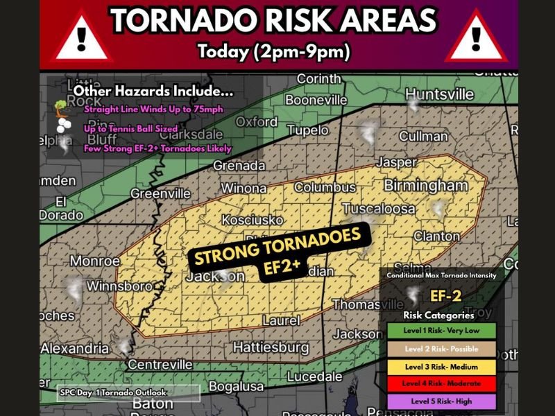
EF-2 Plus Tornadoes, Tennis Ball Hail and 75mph Winds Targeting Alabama, Mississippi and Louisiana Including Jackson, Tuscaloosa and Birmingham Today 2PM to 9PM
ALABAMA, MISSISSIPPI AND LOUISIANA — The first big Dixie Alley severe weather event of the spring is setting up today, Wednesday May 6, 2026, across Alabama, Mississippi, and Louisiana with multiple rounds of supercells capable of all hazards between 2 PM and 9 PM. A few strong EF-2 plus tornadoes are likely across the primary risk zone, accompanied by straight line winds up to 75 mph and tennis ball sized hail. The SPC has mentioned a possible upgrade to Moderate Risk if trends continue supporting a more widespread outbreak scenario.
EF-2 Plus Tornadoes Likely Across Jackson, Tuscaloosa and Birmingham Corridor
The hatched yellow Level 3 core covers a broad area from Jackson, Kosciusko, and Winona through Columbus, Tuscaloosa, and Birmingham. Strong EF-2 plus tornadoes are specifically called likely across this zone, making this the most dangerous portion of today’s event.
Wind shear profiles beneath widespread cloud cover are already described as supportive of large and dangerous tornadoes with any supercell sustaining low-level mesocyclones through the afternoon.
Tennis Ball Sized Hail and 75mph Straight Line Winds Accompany the Tornado Threat
Beyond tornadoes, today’s supercells are capable of producing tennis ball sized hail and straight line winds reaching up to 75 mph across the risk zone. These additional hazards make every storm that develops today potentially life-threatening regardless of tornado occurrence. Storms will develop and intensify after noon with the tornado threat ramping up significantly from there through the 9 PM window.
Moderate Risk Upgrade Possible if Cloud Cover Clears and Outbreak Scenario Develops
The SPC has placed a possible Moderate Risk upgrade on the table if cloud cover clears sufficiently and the widespread outbreak scenario becomes more supported through the early afternoon. Widespread storm coverage moving west to east is expected across the entire risk area.
Residents across Alabama, Mississippi, and Louisiana must seek sturdy shelter immediately when tornado warnings are issued and avoid all unnecessary travel between 2 PM and 9 PM today. Stay with NapervilleLocal.com for the latest weather updates and local forecast coverage.

I’ve lived in Naperville long enough to see how quickly our community changes — from new developments downtown to sudden shifts in our Midwest weather. Reporting on Naperville news and daily forecasts gives me the chance to keep neighbors informed about what really matters. My goal is simple: deliver clear, timely updates so you always know what’s happening in our city and what to expect from the skies above.