
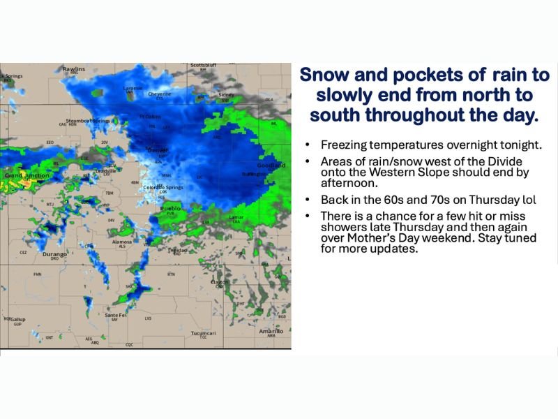
Widespread Snow and Rain Slowly Ending Across Colorado Including Denver, Colorado Springs and the Western Slope Wednesday With Freezing Temperatures Overnight and 60s and 70s Returning Thursday
COLORADO — Widespread snowfall is covering Colorado on Wednesday morning, May 6, 2026, with areas of rain on the far eastern plains and far southern Colorado as the main trough axis swings through from north to south. Snow and rain will slowly end from north to south throughout the day, with the Western Slope clearing by afternoon. Freezing temperatures are expected overnight tonight before a rapid warmup back into the 60s and 70s arrives Thursday afternoon.
Widespread Snow Covering Colorado This Morning With Rain on Eastern Plains
Radar is showing a broad blue snow shield draped across the Front Range, mountains, and northern Colorado this morning. The far eastern plains and far southern Colorado are tracking rain rather than snow as warmer air holds at lower elevations in those zones.
The main trough axis swinging north to south through the day will gradually push the precipitation southward before ending conditions from north to south through the afternoon and evening hours.
Travel Hazardous This Morning With Extra Time Needed Across All Routes
Anyone traveling anywhere across Colorado, Wyoming, Nebraska, or Kansas this morning should give themselves significantly extra time. Road conditions are hazardous across mountain passes, the Front Range, and I-25 corridor with snow covered and slick surfaces widespread.
Road condition resources include cotrip.org for Colorado, wyoroad.info for Wyoming, 511.nebraska.gov for Nebraska, and kandrive.org for Kansas.
Freezing Temperatures Tonight Before Rapid Warmup Into 60s and 70s Thursday
Temperatures will drop to freezing overnight tonight into Thursday morning, making plant protection necessary across the Front Range and surrounding areas. Sensitive plants and vegetation should be covered before sunset Wednesday evening.
Thursday afternoon brings a complete turnaround with temperatures recovering into the 60s and 70s statewide. A few scattered hit or miss showers are possible late Thursday and again through Mother’s Day weekend, but a complete washout is not expected. Stay with NapervilleLocal.com for the latest weather updates and local forecast coverage.

I’ve lived in Naperville long enough to see how quickly our community changes — from new developments downtown to sudden shifts in our Midwest weather. Reporting on Naperville news and daily forecasts gives me the chance to keep neighbors informed about what really matters. My goal is simple: deliver clear, timely updates so you always know what’s happening in our city and what to expect from the skies above.