
El Nino Pointing to Slower Hurricane Season Across Atlantic and Caribbean With Subtropical Development and Gulf Coast Proximity Threat Still Possible August Through October 2026
ATLANTIC BASIN — A strong El Nino pattern is producing one of the most definitive slower hurricane season signals in years, with the European Centre Superblend forecast covering August through October 2026 showing very dry conditions across the Caribbean and Main Development Region. Of all climate phenomena, a strong El Nino delivers the greatest seasonal forecast certainty, and the current signal is pointing clearly toward suppressed Atlantic storm activity during peak season. A slower season, however, is not a no-season, and coastal residents must remain prepared regardless of the overall outlook.
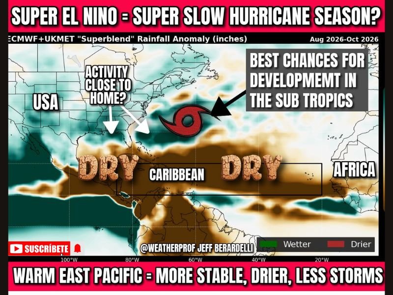
The Superblend model blend shows two unmistakable signals — a dry and hostile Caribbean suppressing traditional tropical development, and the best development chances shifting northward into the subtropics closer to the US coastline. Both signals carry significant implications for how and where storms may develop during the 2026 peak season window.
Dry Caribbean and Warm East Pacific Suppress Traditional Atlantic Storm Development
The pronounced dryness forecast across the Caribbean and Main Development Region reflects the core suppressing influence of El Nino on Atlantic hurricane activity. Warm East Pacific conditions associated with El Nino increase wind shear across the Atlantic tropics, making storm formation and intensification significantly more difficult through the traditional breeding grounds stretching from the African coast westward.
This combination of dry air and elevated shear represents the most reliable recipe for a below average Atlantic hurricane season and is why forecasters are expressing unusual confidence in this year’s slower season outlook.
Gulf Coast and Southeast Face Proximity Threat From Near Shore System Development
Despite the suppressed deep tropics, systems developing near the Gulf Coast or Southeast coast on old frontal boundaries or transitioning upper level lows remain a concern. These near-shore systems tend to be weaker but are capable of producing heavy rainfall and rapid impact given their close proximity to populated coastlines.
Gulf Coast and Southeast residents should treat this forecast as encouraging context rather than a reason to skip preparations. Any storm making landfall is a serious event regardless of seasonal activity levels, and having emergency plans confirmed well before August arrives remains essential. Stay with NapervilleLocal.com for the latest weather updates and local forecast coverage.

I’ve lived in Naperville long enough to see how quickly our community changes — from new developments downtown to sudden shifts in our Midwest weather. Reporting on Naperville news and daily forecasts gives me the chance to keep neighbors informed about what really matters. My goal is simple: deliver clear, timely updates so you always know what’s happening in our city and what to expect from the skies above.