
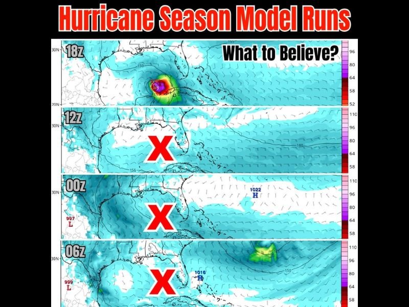
Hurricane Season Model Runs Showing Conflicting Signals With Only One of Four GFS Runs Showing Storm Development as 2026 Atlantic Season Approaches June 1st
ATLANTIC — Conflicting hurricane season model runs are circulating across social media ahead of the 2026 Atlantic Hurricane Season, with only one of four recent GFS model runs showing any storm development while the remaining three show nothing. The GFS 18z run showing a potential storm in the Gulf has been widely shared, but the 12z, 00z, and 06z runs all show red X designations indicating no tropical development in the same timeframe. Forecasters are urging caution against reading too much into any single dramatic model run this early in the season.
Only the GFS 18z Run Shows Storm Development While Three Other Runs Show Nothing
Four consecutive GFS model runs tell completely different stories about early hurricane season activity. The 18z run is showing an intense storm signature in the Gulf region that has driven widespread social media attention and concern.
The 12z, 00z, and 06z runs all show clear red X markings with no tropical development whatsoever in the same area, highlighting exactly why a single model run should never be used as the basis for hurricane season concern or preparation decisions.
GFS Has Been One of the Worst Models for Long Range Tropical Formation Guidance
The GFS model has been identified as one of the worst performing models in recent years specifically when it comes to guessing long range tropical storm formation. Surrounding model runs showing nothing, combined with EURO and ensemble models also showing no development, provides far more meaningful guidance than one dramatic outlier run.
The nature of social media amplifies the most alarming single run while the dozen runs saying no receive virtually no attention or engagement from the public.
Legitimate Hurricane Tracking Requires Ensembles and Patterns Not Single Model Runs
Responsible hurricane season forecasting requires analyzing ensembles, historical weather patterns, jet stream positioning, and multiple model consensus rather than reacting to single dramatic model runs. When a genuine and legitimate tropical threat begins developing, multiple models and ensemble runs will align in agreement rather than showing one hit among many misses.
Residents should remain appropriately prepared for the 2026 season beginning June 1st without reacting to individual model run hype circulating on social media. Stay with NapervilleLocal.com for the latest weather updates and local forecast coverage.

I’ve lived in Naperville long enough to see how quickly our community changes — from new developments downtown to sudden shifts in our Midwest weather. Reporting on Naperville news and daily forecasts gives me the chance to keep neighbors informed about what really matters. My goal is simple: deliver clear, timely updates so you always know what’s happening in our city and what to expect from the skies above.